| UTM-X | UTM-Y | ||
|---|---|---|---|
| STOP 1: PUNTA ROJA HEADLAND | |||
| STOP 2: LA VALL BELVEDERE | |||
| STOP 3: CALA FONTANELLES | |||
| STOP 4: CODOLAR DE BINIATRAM |
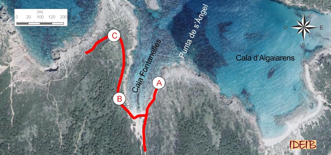
Suggested route to the stopping point and continuation towards the next one.
Take Camí de Cavalls from Algaiarens car park and head for Cala Fontanelles along a section of the trail that has been pretty much covered by sand dragged by the wind. When you arrive, you will be on the eastern edge of the cove, behind a beach cabin called Villa Seca.
Here you will see the grey rocks from the middle Triassic which are Sedimentary rock whose main component is calcium carbonate (CaCO3). Its origin can be chemical, organic or detritic.</p><p><br></p></div>">limestone rocks. These rocks sedimented in a primarily shallow, calm sea, where numerous and varied life forms proliferated. The skeletons of these organisms, very frequently partially or completely broken by the waves, would end up creating a sediment, together with the erosion produced by their activity, and, for example, defecations of animals that fed on organisms with a calcareous skeleton would also become part of the sediment. The cementation of the grains that form the sediment led to the formation of a rock: Sedimentary rock whose main component is calcium carbonate (CaCO3). Its origin can be chemical, organic or detritic.</p><p><br></p></div>">limestone. Consequently, all these rocks contain fossils, which are essential in determining their age.
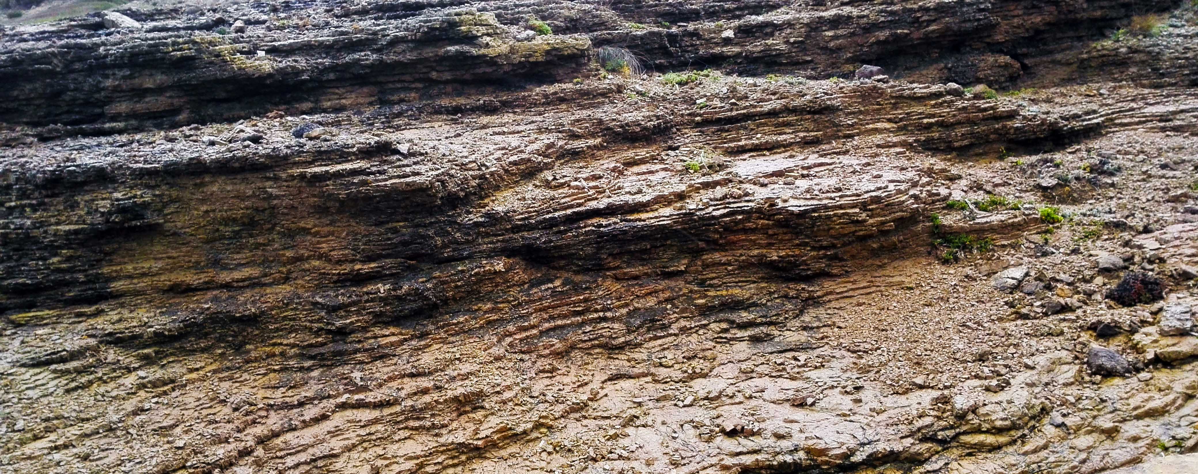
Along the slope at Ses Fontanelles beach and towards the Punta de s’Àngel headland, which demarcates the eastern edge of the cove, the rocks have a different appearance. You will see limestones that form fine layers separated by extremely thin laminae of marls. The marls are soft sedimentary rock with an earthy appearance, comprising a combination of clay and calcium carbonate (such as Sedimentary rock whose main component is calcium carbonate (CaCO3). Its origin can be chemical, organic or detritic.</p><p><br></p></div>">limestone) in many varying colours due to the different components that they may contain and the proportion of them (organic matter, iron, etc.). They are usually sedimented in calm marine and, commonly, lacustrine environments. Consequently, the presence of marls marks a change in sedimentation, which means more clayey soil arriving from continental areas next to where these rocks were deposited, depressing the sedimentation of remains of organisms with shells and skeletons of a calcareous composition.
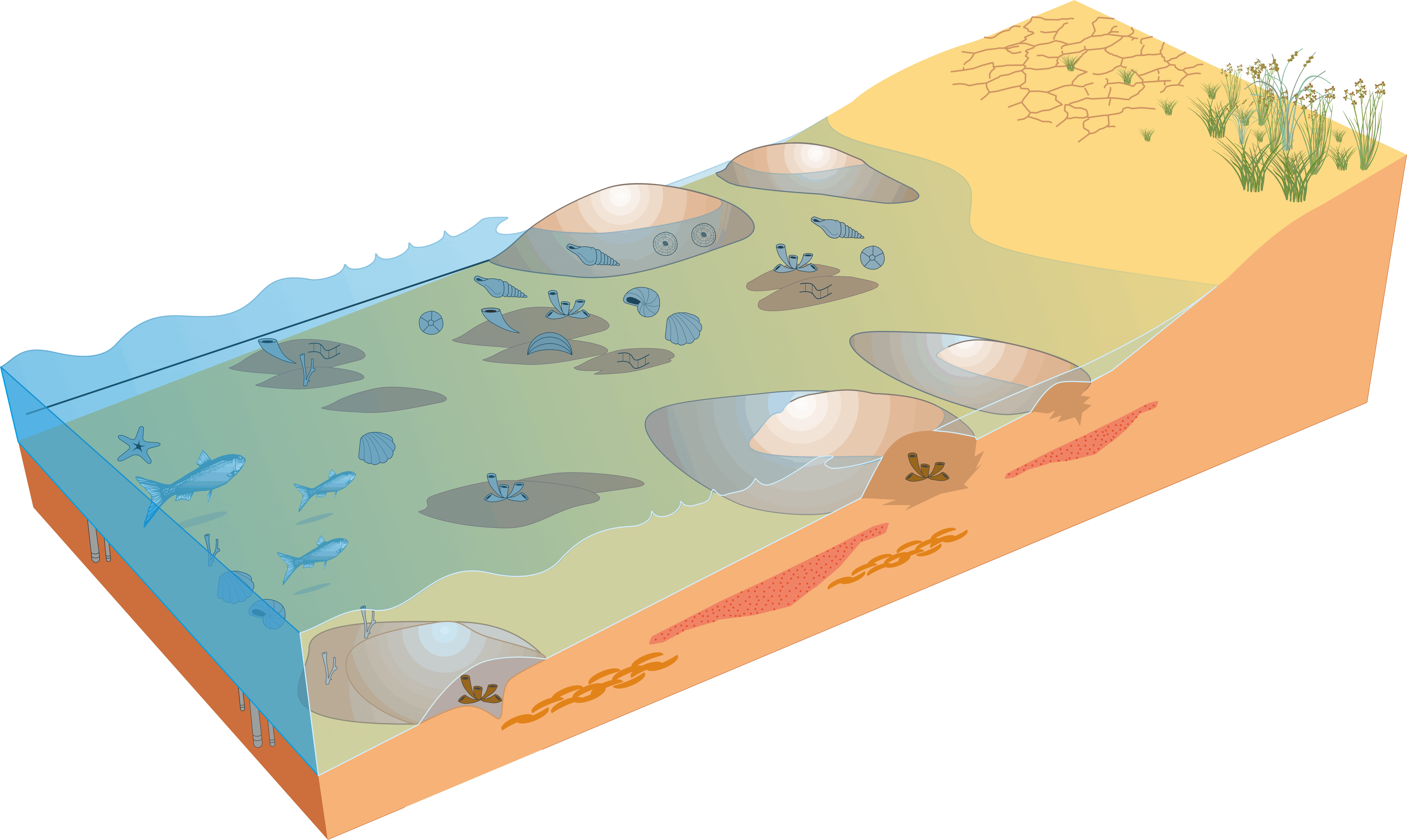
Reconstruction of a calm and shallow sea, with an abundance of organisms, whose activity, together with the shells and skeletons of calcareous organisms, formed a large part of the sediment that would make up the limestone rocks you see at Algaiarens.
Limestones comprising fine layers with small levels of marl interleaved (point A).
Above these rocks, you will see much more massive levels of strata of dolomites (found especially at Punta de s’Àngel). Dolomites were originally Sedimentary rock whose main component is calcium carbonate (CaCO3). Its origin can be chemical, organic or detritic.</p><p><br></p></div>">limestone rocks that were buried and covered by other materials that pressed down on them. Under these conditions and through the presence of water with magnesium, Sedimentary rock whose main component is calcium carbonate (CaCO3). Its origin can be chemical, organic or detritic.</p><p><br></p></div>">limestone can become a dolomite. In other words, it is very common for a dolomite to have originally been a Sedimentary rock whose main component is calcium carbonate (CaCO3). Its origin can be chemical, organic or detritic.</p><p><br></p></div>">limestone rock, made up like all of them of CaCO3. When large volumes of water with high levels of magnesium flowed through these rocks, the calcium (Ca) was replaced by magnesium, which led to the creation of this new rock. During this transformation, a process of crystallisation occurs, the rock becomes a little smaller (around an 11% loss in volume) and the sedimentary structures disappear, as do the fossils, factors that play a huge role in its appearance.
In the sea, at the western edge of the cove, are the Sedimentary rock whose main component is calcium carbonate (CaCO3). Its origin can be chemical, organic or detritic.</p><p><br></p></div>">limestone rocks on the Illot de ses Vinjoles islet, with the unique characteristic that they form a fold. In fact, all the rocks you have seen form folds, but unlike Illot de ses Vinjoles, they are difficult to identify. These folds are associated with the intense movements that affected the Earth from the late Cretaceous (65 million years ago) and that caused a collision between two large tectonic plates: the African plate and the Eurasian plate, which were separated by a huge sea. As these two continents approached each other due to the effect of these movements, the sediments, like those you see at the stopping point that had been formed over millions of years and accumulated at the bottom of the sea basins, steadily transformed into rocks and compressed, creating folds like the ones found at Ses Vinjoles, as these sediments were no longer rigid. This process culminated in the emergence of huge rocky masses from the seabed, creating the great mountain ranges that currently surround the western Mediterranean Sea such as the Baetic Mountains, of which the Balearics, and consequently Menorca, are the eastern tip.

Illot de ses Vinjoles severely folded at the front of Cala de Fontanelles (point A).
In front of the observation point, at the western edge of the cove, is a fossil dune from the Quaternary, with the same characteristics as those identified at the first stopping point and from where numerous blocks have broken off, some of which are large. Some have got as far as the sea while others have not, which, taking advantage of the unevenness caused by the chaotic way they are strewn, were used years ago to build fishermen's refuges. As a result, as these rocks are recent, and consequently not very consolidated, they are very prone to blocks falling away from them Below this dune, you can also find the rocks from the Triassic, in this case they are solely Sedimentary rock composed of clay rich in calcium carbonate. </p></div>">marl deposits that sedimented after the ones on the eastern side of Cala Fontanelles (so the marls were already formed in the upper Triassic). Their location is easy to identify as they are covered in vegetation, although this means you cannot take a close-up look at them.
Carrying on the trail, on the western edge of the cove, you come across the small spring at Cala Fontanelles. In fact, the presence of this spring gives the cove its name. This upwelling is due to the fact that rocks that you can see on top, the consolidated dunes of the Quaternary known as marès, are permeable rocks that allow infiltration and rainwater to flow inside them. Below these rocks are others, the marls from the lower Triassic, which, like all materials with a clayey content, are impermeable rocks. When the infiltrated water comes up against these materials, its way is blocked and it is unable to carrying on flowing inside the rock, leading to it flowing out in the form of a spring. Following the path, in the area around the spring, you can touch the marls at the occasional clearing left by the vegetation and see for yourself its muddy nature.
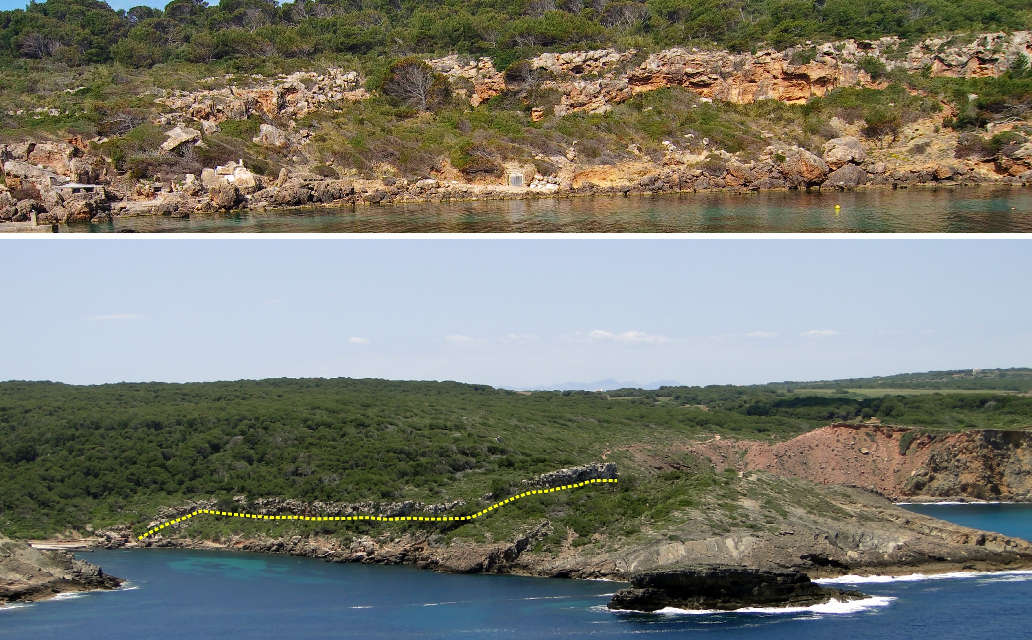
General views of the east side of Cala Fontanelles. Outstanding is a fairly continuous level of fossil dunes in the form of a rock step (the lower limit is marked in yellow) from which numerous large blocks of rock have fallen away. Below this dune, a stretch of vegetation marks the presence of the marls of the upper Triassic (point A). The bottom photograph shows the Ses Vinjoles islet in the foreground.
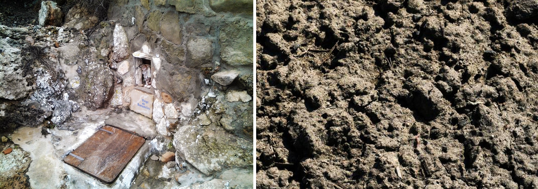
Spring at Cala Fontanelles and earthy appearance of the marls (point B).
Following the Camí de Cavalls, you will come to a high point right at the western edge of Cala Fontanelles, at the Punta de s’Aprés headland. From here, you get great views of the Punta or Penyal de Corniola, a cliff made up of dolomites, like the ones you saw at Fontanelles, but in this case sedimented in the Jurassic, in other words, some 50 millions years later. A little darker than the rocks of the Triassic, these rocks are very strong and resistant and have led to the formation of this promontory. Even so, these cliffs must have been much taller. The strata were sliced through abruptly and intensely eroded to form a peneplain parallel to the sea, in other words, very severe erosion completely destroyed the relief, leaving it completely flat. At the corner of s’Escala that demarcates the headland to the south, the grey of the cliff turns to red colourations at an interesting tectonic, eustatic or antropical processes</span></p></div>">outcrop that is the subject of the next stopping point.
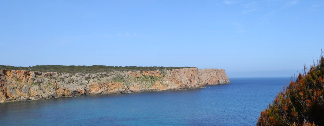
Penyal de Corniola modelled in dolomites from the Jurassic and affected by intense erosion that destroyed the relief and left it completely flat (point C).