| UTM-X | UTM-Y | ||
|---|---|---|---|
| STOP 1: PUNTA ROJA HEADLAND | |||
| STOP 2: LA VALL BELVEDERE | |||
| STOP 3: CALA FONTANELLES | |||
| STOP 4: CODOLAR DE BINIATRAM |
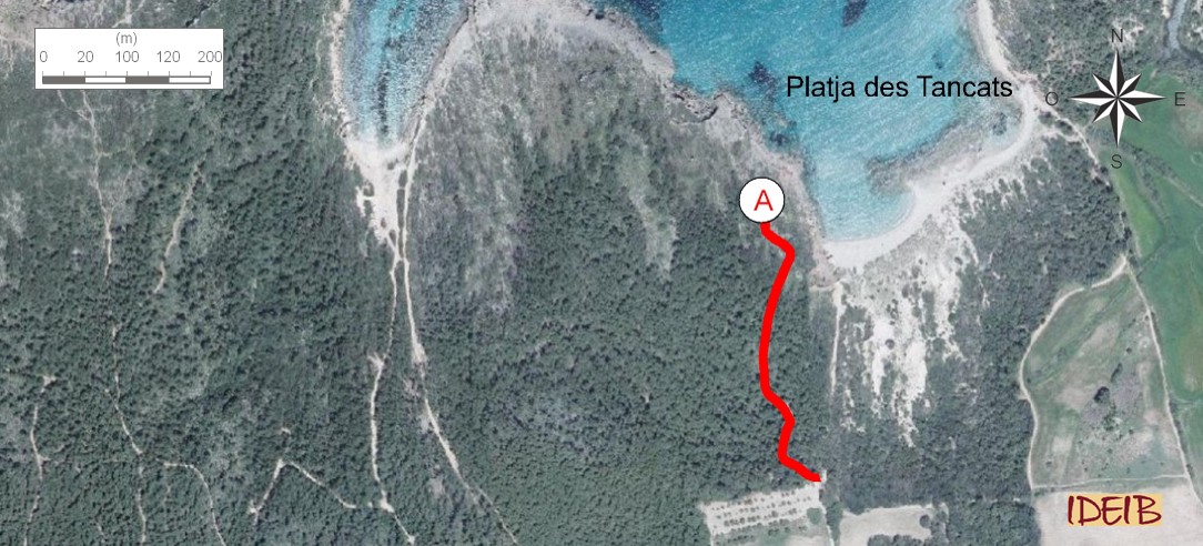
Access route to the stopping point.
Right next to the Algaiarens car park, you will see a trail leading to a belvedere that offers stunning views of the cove. From here, you will see the complete section covered to access the first stopping point. The red materials at Punta Roja sedimented by rivers contrast with the grey materials situated just behind them and deposited in a very different environment, in shallow waters of the sea. At the top, the inclined rocks have been sliced through by a dune deposited much later, in the Quaternary.
Coastal section from Punta Roja to Platja des Bot beach from the Algaiarens belvedere (point A).
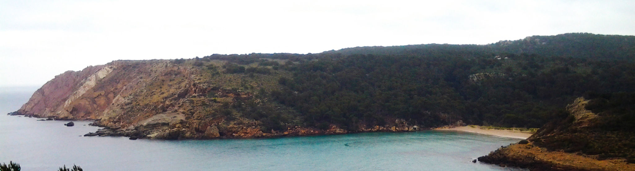
Between the Es Bot and Es Tancats beaches stands the Puig Tremolor hill, which enters the sea at the Punta des Vernís headland, and is modelled in the same grey rock identified near Punta Roja. Below it, and right next to Es Tancats beach, you will find the stunning red rocks, made from the same materials as described in the information at the first stopping point on the route. As indicated, these rocks were sedimented by rivers in the lower Triassic, specifically between 260 and 240 million years ago, and immediately afterwards, in the middle Triassic, the grey rocks sedimented in the sea, which is why they are found above the red rocks. They are limestones and dolomites sedimented in a calm and shallow sea. In other words, after the fluvial processes that caused the predominantly red series, a rise in the sea level led to a radical change in the type of sedimentation.
At Es Tancats and other beaches, such as Cavalleria, El Pilar and Binigaus, this red clay is very often applied to the skin for supposed therapeutic purposes. These activities pose a huge problem, as they entail the disappearance of some very ancient rocks, erode the cliffs and consequently cause rockfalls (also posing a risk to bathers), vegetation to be uprooted and the deterioration of the habitat of a variety of species.
Puig Tremolor is modelled primarily from limestone and dolomites, although its lower part, where it reaches Platja des Tancats, contains interesting sandstones and red clays (point A).
The fact that Cala d’Algaiarens is divided into two beaches is due to the different hardnesses of the rocks forming it. Consequently, as happens with a lot of the Menorcan coastline, at Algaiarens the most resistant and strongest materials, such as the sandstones, limestones and dolomites, give rise to promontories, such as Punta Roja and Punta des Vernís, while weaker and more easily-eroded rocks, such as clays and marls, you will now see as coves and inlets, such as Platges des Tancats and Platja des Bot.
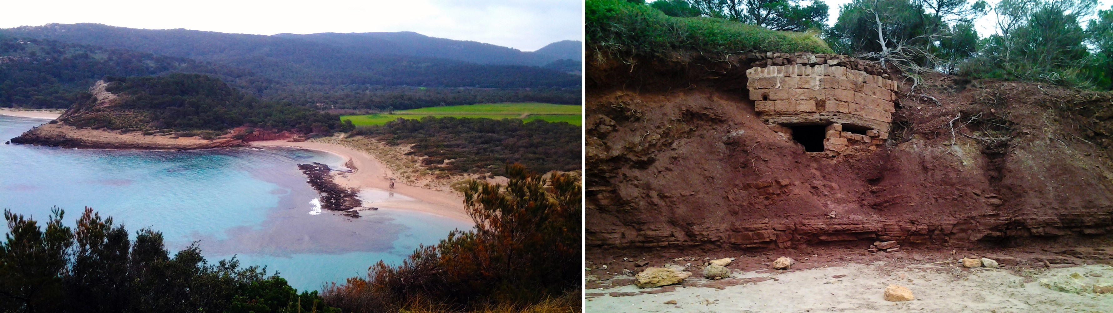
These beaches were created from the mechanical erosion of the waves, but especially due to the action of streams that have excavated the rock, giving rise to these inlets. Today, the main stream that drains the Algaiarens area (the brook on the islet) flows into Platja des Bot; in the months with more rain, it creates a marshy area, and in the drier summer months, the mouth is covered up by the sand deposited by the waves.
Before, instead of flowing into Platja des Bot, this stream flowed into Platja des Tancats, but it was an extremely more energetic stream than it is today: a river with a greater erosive capacity, probably associated with times when the sea level was lower than it is now. This energy enabled the river to carry large cobbles, which it deposited on the beach, right by the mouth. The gaps that there were between the cobbles that sedimented filled with sand, which over time and due to the action of a calcareous cement, petrified and formed a rock that we call sedimentary rock of detritic origin (clasts larger than 2 mm).</p></div>">conglomerate (made up of more or less rounded cobbles joined by the sand).
Conglomerates are very resistant and created a dam that prevented the stream from flowing into Platja des Tancats. Given this, the stream had to create a new river mouth, a much simpler way of allowing the water and sediments it was transporting to flow out. And it found it very close by, right on the other side of Puig Tremolor, where thanks to its erosive power, the stream carved out a new route to the sea through the softer materials and helped form the Platja des Bot beach You can easily see these conglomerates right in front of the lifeguard station where they divide Es Tancats in two.
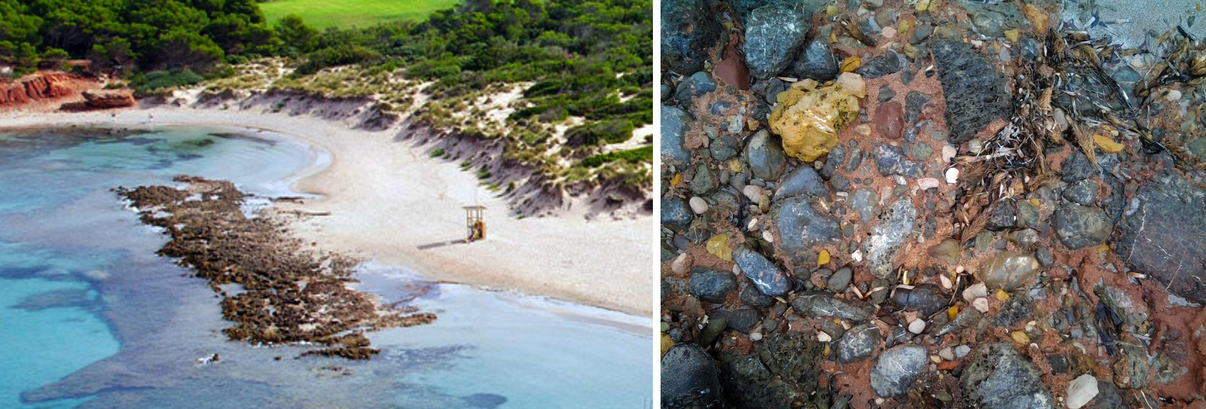
Conglomerates at Platja des Tancats sedimented by the La Vall stream (point A) and close-up of the cobbles and the sand that binds them together)
Behind the beaches, you can see the valley after which the site is named. A flat valley, open to the Tramuntana wind that, just a few thousand years ago, at a time when the sea level was lower than it is today, caused the sand in the cove to be blown inland. On reaching the initial elevations demarcating the valley, which at that time formed a barrier, most of the sand stopped, but when the wind was strong enough, some of the grains passed over this relief, arriving in the southern Migjorn region, and the finest particles even passed right over the island and returned to the sea from the south. The sand at La Vall, and at other sites in Menorca, such as Tirant, has been mined for use as aggregate in the construction industry. Today, the sand is still blown inland by the Tramuntana wind, so this phenomenon of being transported inland will persist, but with much less intensity as sea levels are higher and therefore the extent of the beach is more reduced. Also, the sand is not moving towards the interior of the island with such force because it is fixed in place by the roots of the vegetation.