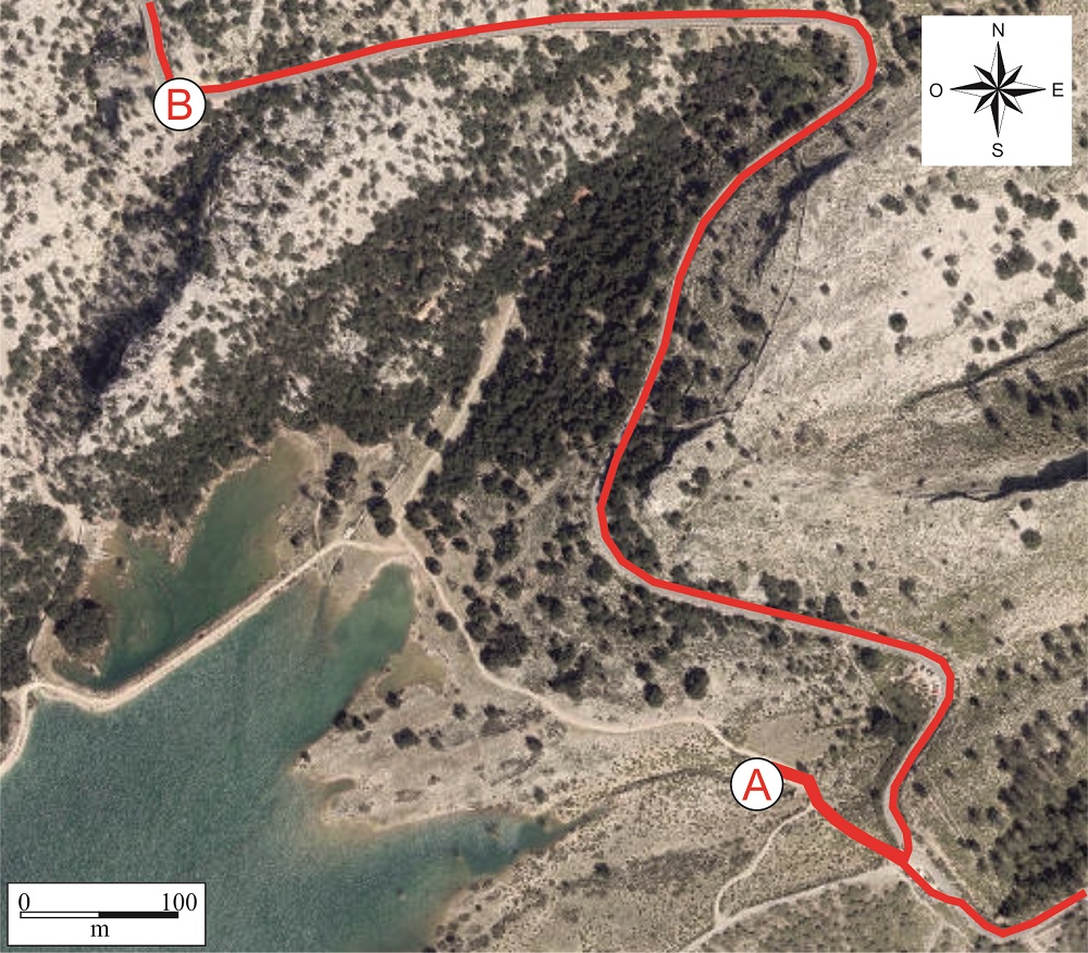
Recommended route. Cúber reservoir (A) and viewpoint (B)
The next stop is the Cúber reservoir, which has a capacity of 4.64 hm3 and is closed by a linear gravity dam. It receives water from the Gorg Blau reservoir by way of a duct which runs in part through pipelines and in part in the form of a canal. Another duct runs from the Cúber reservoir to the Lloseta treatment plant and, from there, goes to Palma.
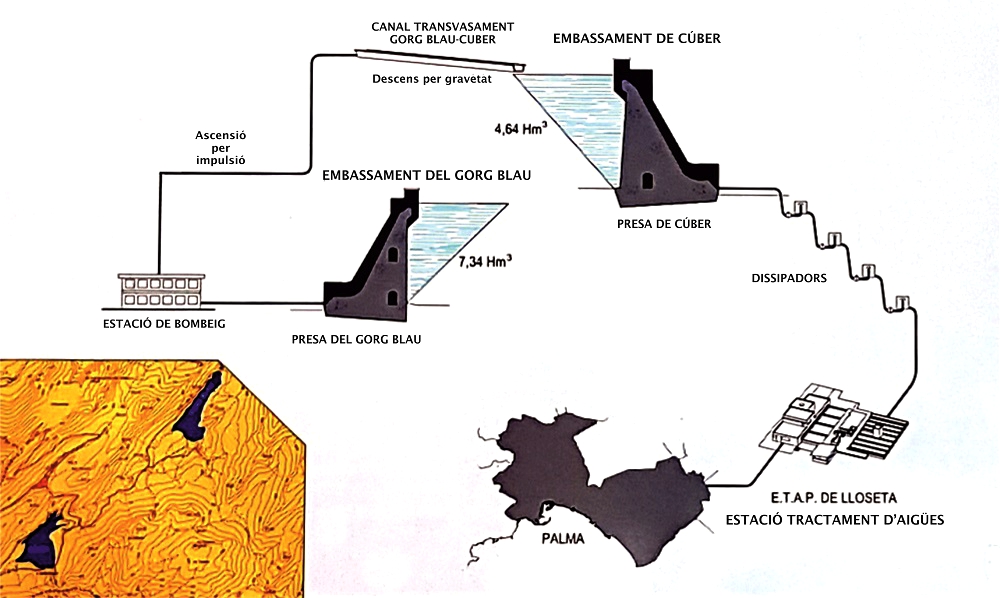
Functioning of the dam and reservoir dam system. EMAYA
At point A of the stop we see precisely the end of the duct that runs between Gorg Blau and Cúber.
At the same point, in addition, we will observe a rocky slope formed by an alternation of hard rocks (limestones) and soft rocks (marls) which display a certain inclination.

Outcrop of an alternation of limestones and marls of the Upper Jurassic.
This inclination of the strata, called stratification plane.</p><p><br></p></div>">dip, is measured by geologists with a special instrument named inclinometer which measures the orientation and stratification plane.</p><p><br></p></div>">dip of the strata. These data are very important for drawing up a structural model of the zone.
These layers were formed on a seabed and contain fossils of ammonites, a type of extinct cephalopod molluscs which had a segmented external shell that allowed them to regulate their floatability. They are related to the modern-day nautiluses and constitute a fundamental element of biostratigraphy, which serves, among other purposes, to determine the relative ages of rocks by analysing their fossils. The ammonites are important in this respect thanks to their relative abundance, great diversity and rapid evolution from one species to another.
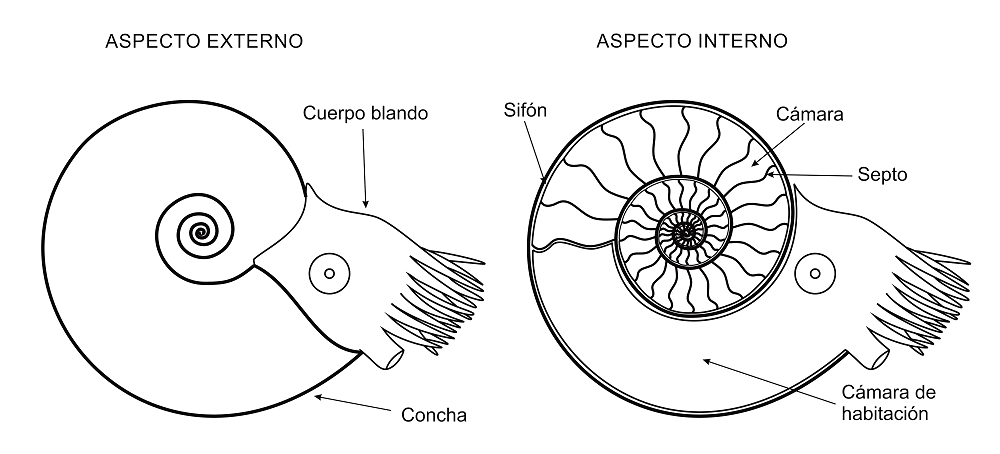
Diagram of the exterior and interior of an ammonite.
If we were to gradually measure the stratification plane.</p><p><br></p></div>">dip of the layers in a NW direction, we would see that it varies and changes direction approximately in the centre of the valley. If we add that the age of the strata (based on the presence of ammonites) is greater at the ends than in the centre of the valley, we conclude that this is a syncline, that is, a concave fold in which the oldest materials are at the ends and the more modern ones in the centre.
As, moreover, the axial plane (which divides the fold into two symmetrical parts) is not vertical but displays a certain inclination, it is called an overturned syncline. This type of tectonic structures, along with thrust faults, is very characteristic of the Serra de Tramuntana.
In the Cúber area there are two overturned synclines separated by an fold in which the oldest materials are situated in its core.</p><p><br></p></div>">anticline (see diagram).
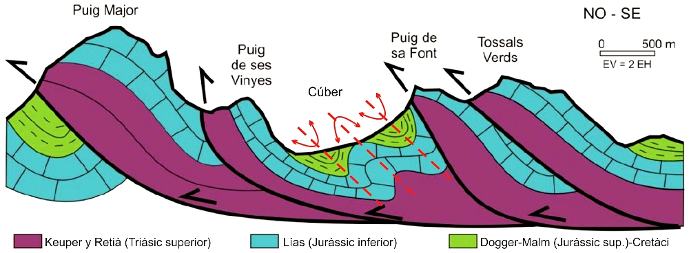
Schematic geological cross-section of the zone of the Cúber reservoir (modified from GEOLODIA 2018).
The strata observed here correspond to the Cúber Formation, and this tectonic, eustatic or antropical processes</span></p></div>">outcrop assisted in its characterisation. In addition, the Gorg Blau Formation has been defined in the area between the two reservoirs. The Gorg Blau Formation straddles the end of the Lower Jurassic or Lias and the beginning of the Middle Jurassic or Dogger, representing an interval between approximately 180 and 170 Ma. The Cúber Formation, for its part, covers a much shorter period, approximately the next two million years, although with an extensive stratigraphic record. Apart from these, in the vicinity there are other geological formations which represent the Upper Jurassic or Malm and reach the start of the Cretaceous (some 145 Ma).
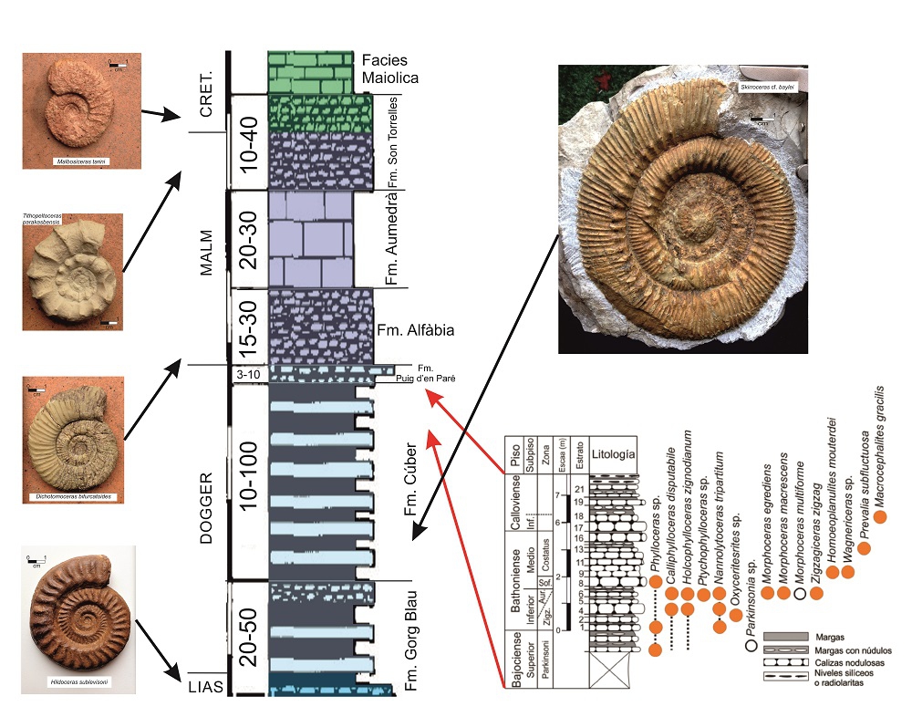
Synthetic stratigraphic column of the geological record of the Cúber zone, with some ammonites representative of different ages. In the bottom right corner, a stratigraphic column of the cross-section existing in the Cúber, with the different ammonites identified and their location, Taken from Juárez & Sandoval (2018).
As the materials of the Middle-Upper Jurassic have little permeability and therefore hamper the filtration of water, they are ideal for installing a reservoir. However, shortly after the Cúber dam was built, problems of water filtration began to occur in a small area to the north-west, where the marls of the Middle-Upper Jurassic was in contact with karstified limestones of the Lower Jurassic, and a contention dike had to be built, running along a part of the path around the reservoir.
Continuing along the Ma-10 road, at km point 35+125 there is a viewpoint, an excellent spot that makes it easier to appreciate the structure of the Cúber valley, where the mountainous escarpments correspond to the fault
<div class="ql-editor"><p class="ql-align-justify">Inverse fault in which the stratification plane.</p><p><br></p></div>">dip of the fault plane is at a low angle (generally less than 45<sup> o</sup>). It tends to refer to large-scale (regional) structures.</p><p><br></p></div>">thrust fault fronts of the materials of the Lias (Lower Jurassic) which lie over the folded materials of the Dogger and Malm (Middle-Upper Jurassic).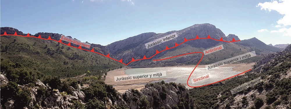
Panorama of the Cúber reservoir from the viewpoint, with its geological structure drawn schematically.