The Trebalúger ravine, which is more irregular and more extensive than the Albranca ravine, has two different branches (the Trebalúger stream to the west and the Albranca and Son Fideu streams to the east) that rise in the north near the village of Ferreries and merge at Son Olivar, very close to the sea. The eastern branch covers 11 km, while the western branch covers around 7 km; 1.6 km complete the configuration of the ravine. It comprises deep fluvial canyons with almost vertical walls cut into the Miocene marès and inclines of around one hundred metres.
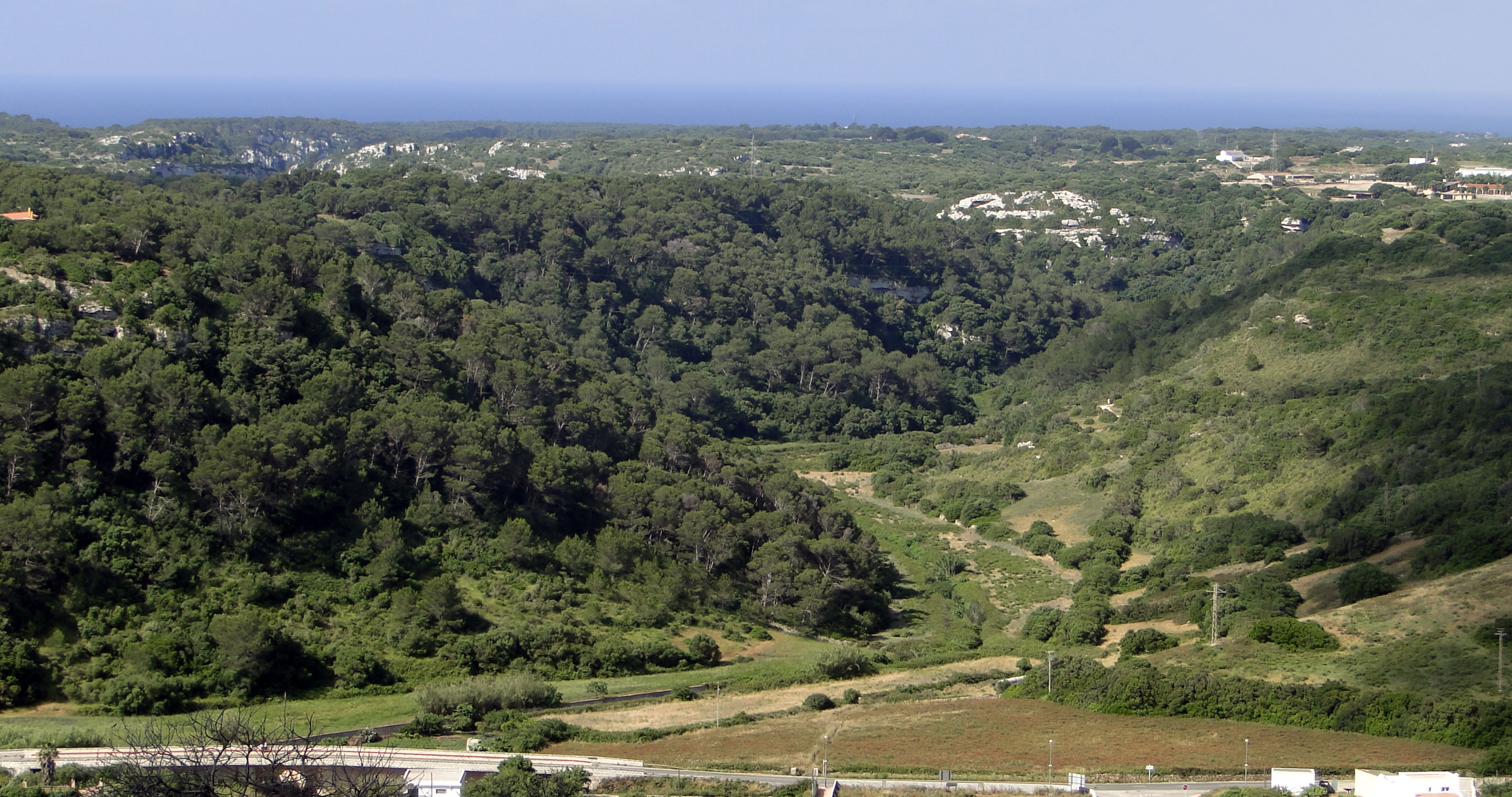
Head of the Trebalúger ravine near the village of Ferreries.
Although it has an overall direction, the ravine describes numerous twists and turns over a very long fluvial section. This winding route is associated with large-scale collapses that reveal false meanders. In other words, although these winding bends in shore erosion could be partly down to rivers (and therefore meanders), their origin is linked to the collapse caused by the dissolving of the rock (known as karstification) by underground water. Karstification of the rock can cause the cave and gallery ceiling to collapse, forming circular or elliptical depressions of varying sizes known as sink holes, which occurred on the sides of the ravine, so widening its river bed. Consequently, the numerous half-moon shaped collapses along the side of the ravines at the Site of Geological Interest, of which there are around forty, were created when underground water dissolved the rock, giving them the appearance we see today. The falling of rocks from the cliffs leads to their retreating and the semicircular morphology of these collapses gives it a meander-type appearance.

At the Albranca and Son Fideu ravines (as well as the others in the central part of the Migjorn region of Menorca), you can see a winding route created by the collapses that affected the sides of the ravines.
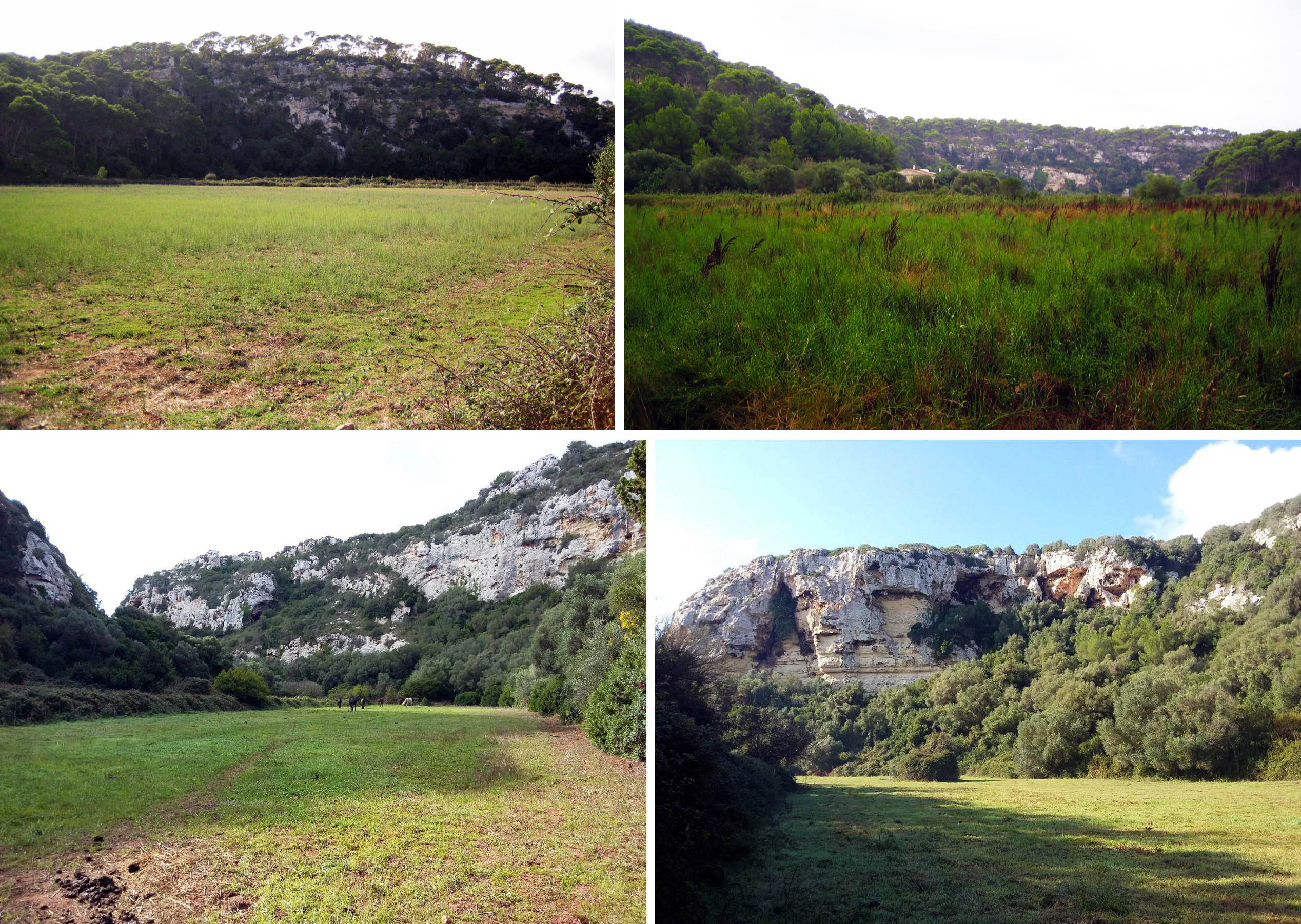
In the lower reaches of the Trebalúger ravine, the walls demarcate wide areas that were once used for crop growing.
The final section of the ravine has a greater flow than the Algendar ravine, although it has fewer springs. There are five springs with water, with a greater or lesser flow, which appear due to the topographical interception of the Top level of subterranean water where the hydraulic pressure is equal to the atmospheric pressure.</p><p><br></p></div>">water table, and records show that at least three more stopped gushing at the end of the 1980s (around Son Fideu and Son Camaró), although there must be more from which water no longer flows. A ravine is a sharp incline in the land surface, which is usually due to erosion caused by a river. If the incline is sufficient to intercept the Top level of subterranean water where the hydraulic pressure is equal to the atmospheric pressure.</p><p><br></p></div>">water table (the upper part of the aquifer) it will supply the stream with water. When this interception occurs above the lamina of water carried by the stream, the water may appear as springs.
The drainage of the stream that flows through the Albranca ravine begins at Son Carabassa, through the spring that gives the ravine its name. At the Trebalúger ravine, the first spring to be identified is the Na Joana spring. It should be noted that the flow of the stream lessens towards the area around the intersection of the two ravines, especially due to the effect of infiltration. Very close to where the Albranca and Trebalúger ravines cross, you will see the powerful Son Olivar spring. In the last section of the ravine, the flow of the stream is increased thanks to the Matacristos and Trebalúger springs, which are very near the beach, helping to make this final stretch rather powerful.
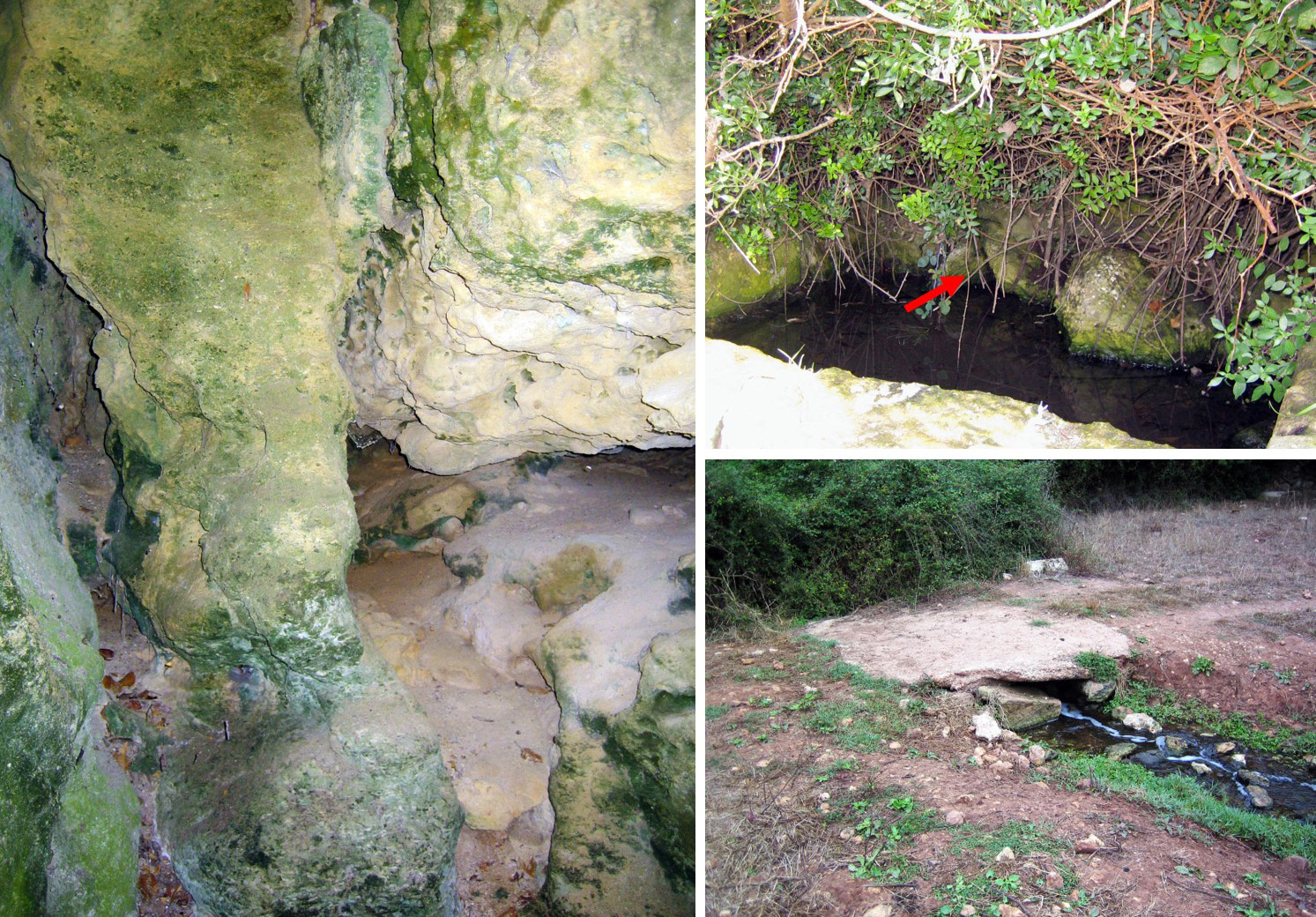
The Na Foradada spring, which stopped flowing due to the drop in the water table that has affected the island’s aquifers generally since the 1980s. The Trebalúger spring (the arrow indicates the small channel through which the water flows out of the spring) and runs off from the Son Olivar spring, which is heavily covered by vegetation.
The flow of the streams in the ravine is highly irregular, in other words, despite receiving water from new springs downstream, at some points, less water runs along its bed. This is due to the different behaviour of the stream, which goes from receiving water from the aquifer to giving it in some places where the water table is lower.
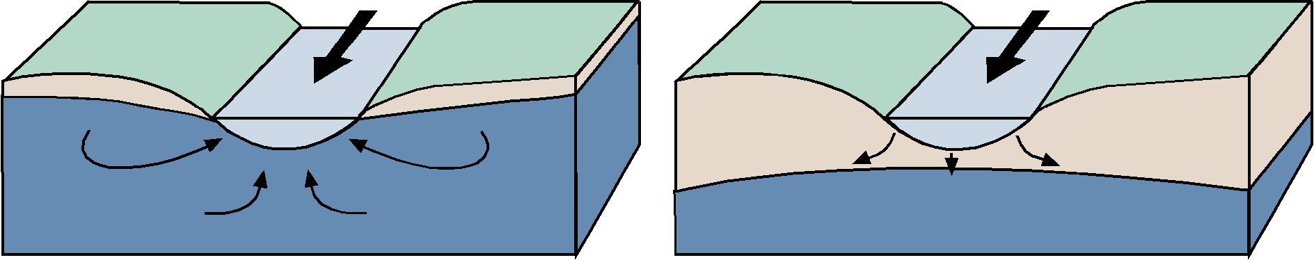
These deep ravines are only found in the central part of Menorca’s Migjorn region. This is because the region is slightly convex due to the action of tectonic movements, with maximum rising in this central part (area with the most curvature), forming what in geology is known as an ‘anticlinal’ structure. Associated with the rising of this central part is the appearance of a series of fractures, which, as they are in the weakest areas of the rock, would be used by the streams to establish themselves and affect the Tramuntana area. As well as all these tectonic movements, we should remember the drops in sea levels that occurred worldwide during the Quaternary, which led to a rise in the slope and, consequently, gave the streams great erosive power, sweeping and dragging the rock and sediments towards the sea. A later rise in sea levels some 10,000 years ago stopped and reversed this process, in other words, it created the stream’s generalised sedimentation in its lower reaches and refilled the coves with sediments.
Consequently, in its final section, the Trebalúger ravine displays a silt and sand filling from the Holocene (the most recent geological era) of up to 10 metres thick, caused by a rise in sea level (leaving it practically at today’s level) which would mean the invasion of the areas that were more widely excavated at the time the streams were formed. This rise in sea level led to the creation of an estuary that would produce sedimentation until its current layout was completed. This way, the last part of the ravine, and therefore the part closest to the cove, has filled with marine sediments and from the lagoons.
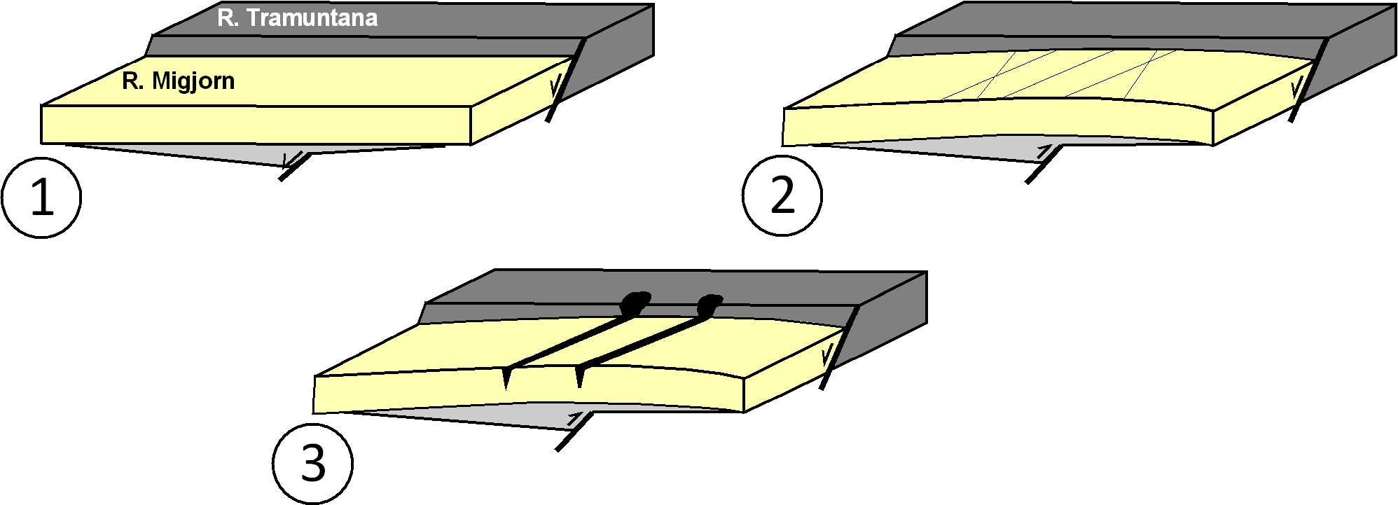
Evolution of the Migjorn region that would lead to the formation of the deep ravines in its central area. Marine sedimentation in the Migjorn region during the Miocene was created by its sinking compared with the Tramuntana region (1). In the late Neogene – early Quaternary, the region gently folded, favouring the appearance of fractures in the area with the greatest curvature (central area of the region) (2). These fractures were used by the drainage system due to their layout, which even went as far as the Tramuntana area, so favouring their incision to create a larger area and the formation of the deep ravines at a time when sea levels were lower (3) (modified from Gelabert et al., 2005).