In addition to being the highest peak of the Balearic archipelago, with its height of 1,445 metres, the Puig Major constitutes an excellent spot for observing the tectonic structure of the Serra de Tramuntana.
The Tramuntana range originated during the Alpine Orogeny, a stage of intense geological activity that commenced some 25 Ma ago. In this period, the materials of the earth’s crust fractured and were piled up onto each other by means of inverse low-angle faults: these are called thrust faults, and when they are superimposed they are said to be imbricated.
In general, thrust faults are made possible because a hard material, in this case the Lias (Lower Jurassic, 201-175 Ma) slides over a soft material, in this case the Keuper and Rhaetian (Upper Triassic, 237-201 Ma), which is called the decollement level.
As a result of this structure, the mountain range presents abrupt escarpments and cliffs in its NW slopes (as in the zone of Sa Calobra), while in the SE the slopes descend gently towards Es Raiguer (Inca zone). The orientation of these asymmetric reliefs indicates the direction in which the tectonic forces acted, in this case SE-NW.
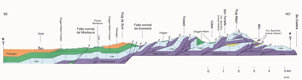
General structure of the Serra de Tramuntana in its central area (modified from Gelabert, 1998).
At a lesser scale, the general structure of the range continues to be maintained. A good example is the massif of the Puig Major, formed by several thrust laminas of the Lias and Rhaetian (Lower Jurassic – Upper Triassic).
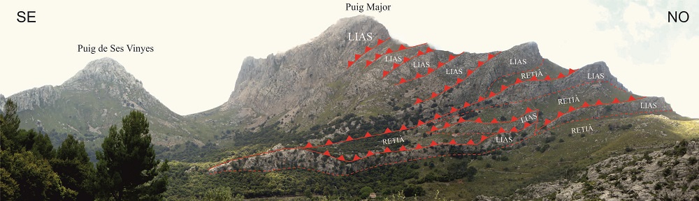
Detailed view of the structure of the Puig Major from km point 27.200 of the Ma-10 road.
As this is such a large structure, it can only be viewed from a distance, either from the Ma-10 road at p.K. 27+200 or from near the Coll de Cals Reis on the MA-2141 road to Sa Calobra.