Situated in the S’Albufera des Grau Natural Park, Illa d’en Colom island is one of the main sites of mineralogical interest in Menorca, due to the concentrations of metallic sulphuric minerals that were once used in incipient mining work.
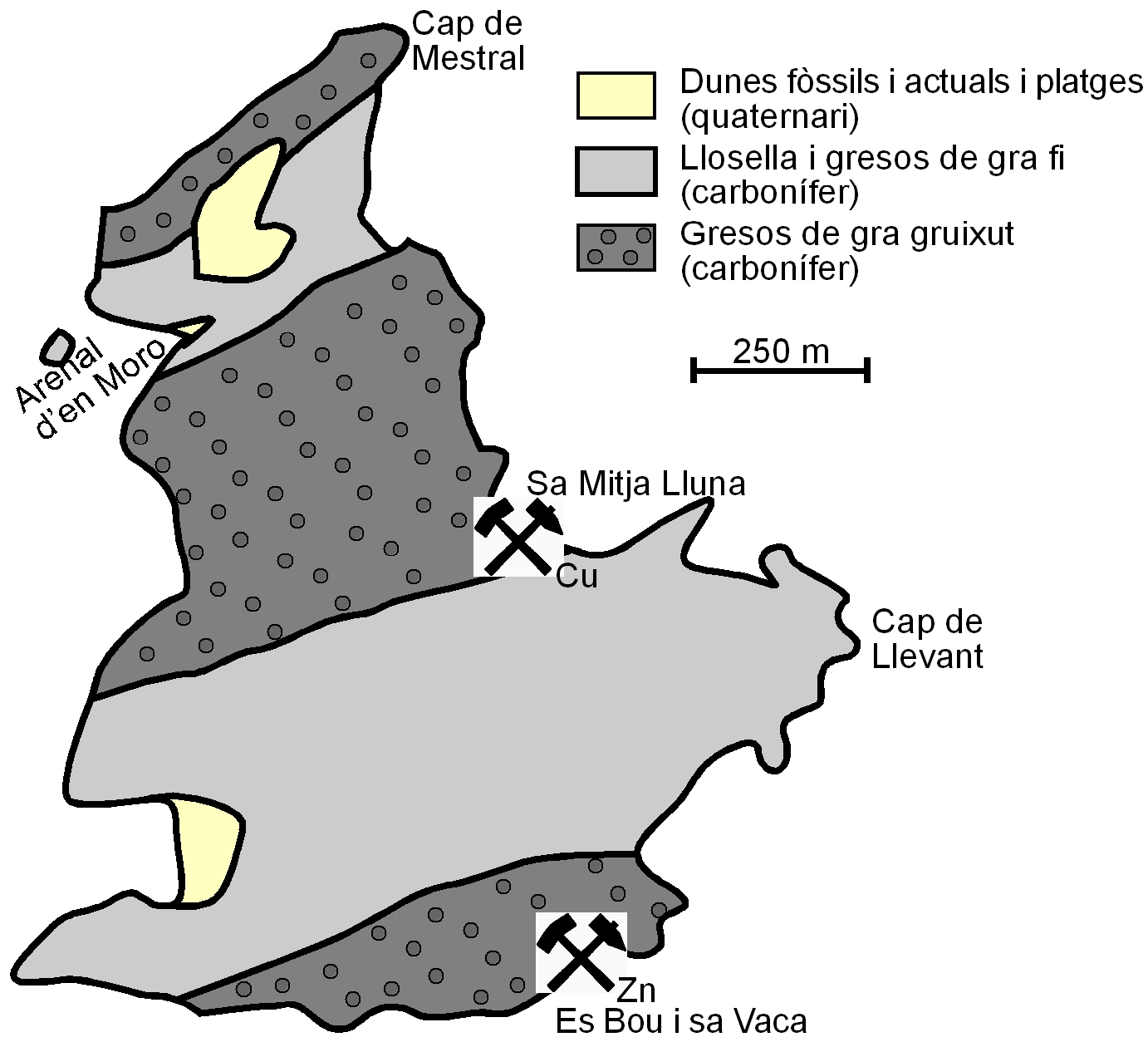
Geological map of Illa d’en Colom and sites of the two mines operational in ancient times on the islet (simplified map by Rosell, J., Gómez-Gras, D. & Elízaga, E. 1989. Geological map of Spain, scale 1:25.000. Page no. 647, IV (Maó – Illa d’en Colom). Spanish Geological Survey. Madrid.
The islet is home to two mining sites, one in its centre on its eastern edge, at the tiny inlet called Sa Mitja Lluna, where copper mineralisations were extracted. The other is in the south of the islet, on the Es Bou i Sa Vaca cliff, and is where zinc minerals where extracted. In the rubble at the Sa Mitja Luna copper mine, ceramic fragments dating from the Bronze Age were discovered together with remains of prehistoric stone tools. This copper mine is the only one from prehistoric times to be documented so far in the Balearics, although there must very probably be others, but traces of it have been lost due to subsequent mining activity conducted. This copper mine would have been particularly active in the first quarter of the twentieth century, just like the zinc mine, which was registered in 1902, shortly after work started here, but where mining would have continued after copper extraction had ceased.
Geological map of Illa d’en Colom and sites of the two mines operational in ancient times on the islet (simplified map by Rosell, J., Gómez-Gras, D. & Elízaga, E. 1989. Geological map of Spain, scale 1:25.000. Page no. 647, IV (Maó – Illa d’en Colom). Spanish Geological Survey. Madrid.
be others, but traces of it have been lost due to subsequent mining activity conducted. This copper mine would have been particularly active in the first quarter of the twentieth century, just like the zinc mine, which was registered in 1902, shortly after work started here, but where mining would have continued after copper extraction had ceased.
The mines are not located in the east and southeast of the islet purely by chance. The rocks in this part of Illa d’en Colom are rather deformed. As a result of this deformation, the rocks have broken into numerous fractures through which hydrothermal fluids flowed which, laden with silica, would eventually precipitate as different minerals.
Quartz was the most abundant of these mineralisations to be extracted. However, there were also small precipitations in the form of iron sulphides, the mineral we know as chalcopyrite, and copper sulphides, which through contact with the outside world are found in a highly-altered state in minerals such as azurite (strident blue) and particularly malachite (a no less striking green). Brown-red iron oxides, such as haematite, have also been identified.
The mineral that was mined on the Es Bou i Sa Vaca cliff was a blende, a zinc sulphide that is usually accompanied by a small amount of silver. The blende is embedded in lodes of white quartz that would have refilled the fractures that had opened up in the rock. The lodes are not large, which gives a sense of the low yield of the mine, although they are thicker than the copper lodes mined at Sa Mitja Luna.
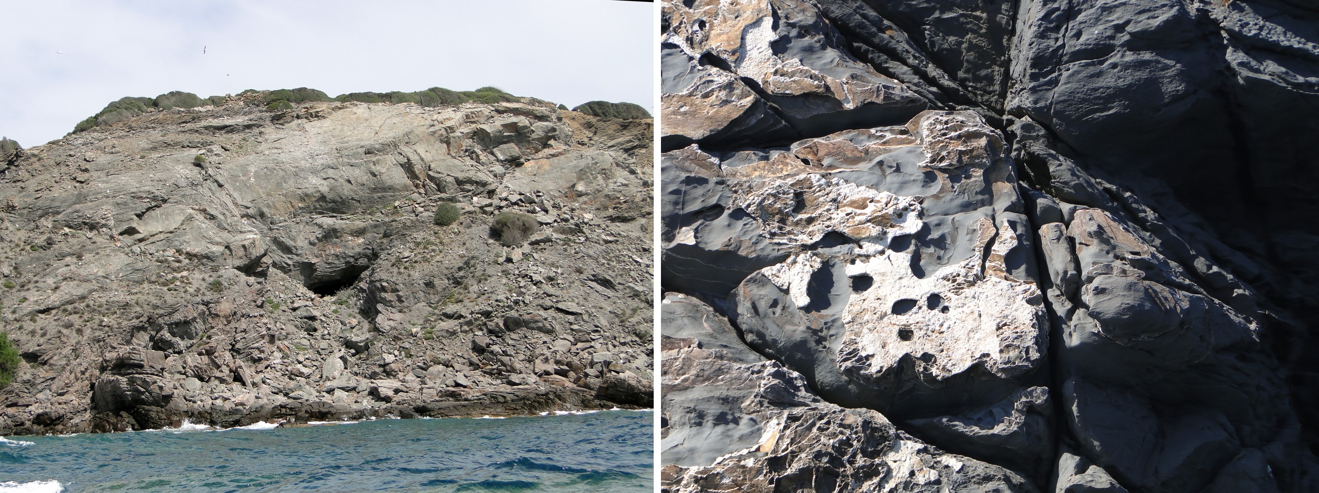
Lower entrance to the blende mine on the Es Bou i Sa Vaca cliff, somewhat hidden by rockfalls. The collapsed roof at the entrance to the mine has made access to it almost impossible, making it very dangerous to enter. To the right, quartz mineralisations in the flat surface left by a fracture, where fluids flowed that precipitated minerals. The considerable rock fractures in the east and south of the islet led to the build-up of accumulations of quartz associated with copper and iron (chalcopyrite) and zinc (blende) mineralisations, which were worked at the Sa Mitja Lluna mine and at the Es Bou i Sa Vaca cliff respectively.
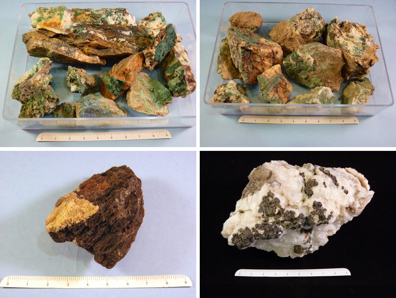
Minerals collected on Illa d’en Colom island and deposited at the Menorca Geology Centre. Quartz with high levels of malachite (green) and azurite (blue) (top left) and malachite and chalcopyrite (grey) (top right). Haematite (red) (bottom left) and quartz (white) with blende (grey) (bottom right). This last example clearly shows how the quartz lodes contain minerals of interest to mining.
The islet forms part of the geological series sedimented in the Carboniferous and makes up most of the north of Maó. The sediments comprising it were deposited around 350 million years ago at great sea depths by turbulent currents that began on the continental shelf and that over time formed successive layers of sandstones and lloselles. Of particular interest is the tectonic, eustatic or antropical processes</span></p></div>">outcrop that you can see in a corner between the Cap de Mestral headland and Sa Mitja Lluna. Here, the cliff comprises a series of layers of black sedimentary rock which tends to exfoliate in small flakes, similar to sedimentary rock formed by clay.</p></div>">pelite. </p></div>">llosella on top of which there is another series of brownish sand-sized clasts.</p><p><br></p></div>">sandstone where the grains of sand make it rather coarse-grained. The contact between the two is very clean and clear.
Contact between the coarse-grained sandstone and the black llosella below, near Cap de Mestral. Despite its massive appearance, the layers of sandstone are interleaved with very thin layers of rocks containing very fine grains. The same occurs with the llosella, inside which layers of fine-grained sandstone have been identified.
When these sediments reach the abyssal plain, they create an underwater delta with similar characteristics to a flood plain. On the delta that has developed at great sea depths, differentiation should be made between a grooved part closer to the talus and another further away or distal, depositional part. In the grooved part, currents travel confined to the depressions forming the channels. When the channel ends, the currents stop, as they cannot transport the material any further and they deposit it quickly. Due to its volume, when the turbulent current overflows, it invades a larger space than the channels and sediments the finer materials more slowly in a process that may take a day. These materials create the sedimentary rock which tends to exfoliate in small flakes, similar to sedimentary rock formed by clay.</p></div>">pelite. </p></div>">llosella that you can see at the bottom of the tectonic, eustatic or antropical processes</span></p></div>">outcrop, while the sand-sized clasts.</p><p><br></p></div>">sandstone at the top comes from the sand that was dragged along the channels. We should point out that both types of rock correspond to different episodes of flooding over time.
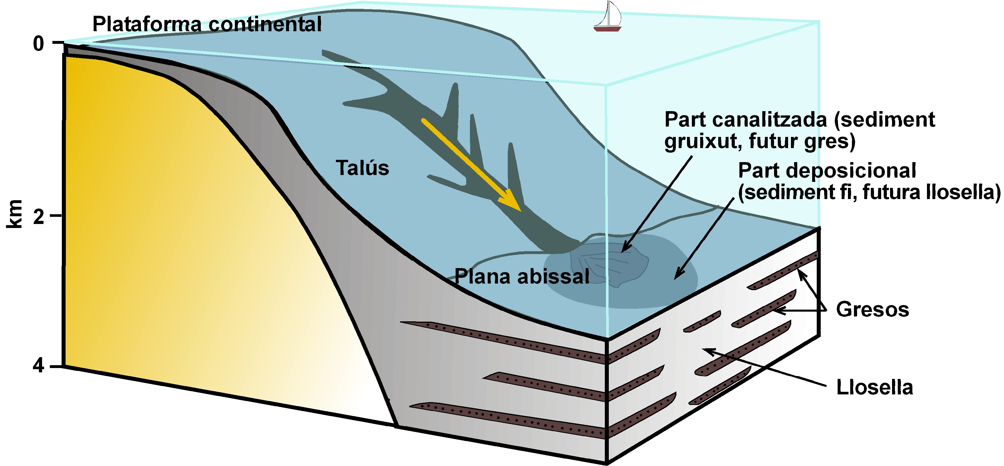
When it reaches the abyssal plain, the turbulent current first sediments the coarser grains along the talus, whereas it takes longer to sediment the finer grains and in an area further away from the talus.
Due to the effect of the salt-laden wind, the sand-sized clasts.</p><p><br></p></div>">sandstone layers present alveolar or honeycomb erosion and also bowl disjunction, where weathering has created a series of spherical shapes as one part of the rock is more resistant to erosion than the rocks around it. These types of rocks can be seen at S’Arenal d’en Moro beach. To the south of the cove, we find the coarse-grained sand-sized clasts.</p><p><br></p></div>">sandstone layers that protect the beach, helping prevent sand loss, while the northern edge is dominated by the sedimentary rock which tends to exfoliate in small flakes, similar to sedimentary rock formed by clay.</p></div>">pelite. </p></div>">llosella where we find numerous trace fossils or ichnofossils of different species, in other words, traces left in the sediment by organisms that did not fossilise but whose activity has been “etched” into the rock.
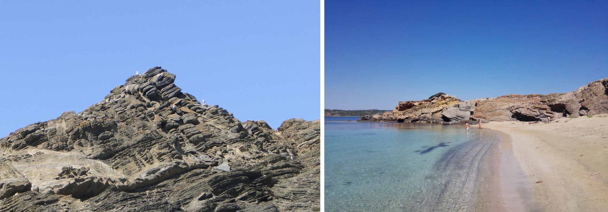
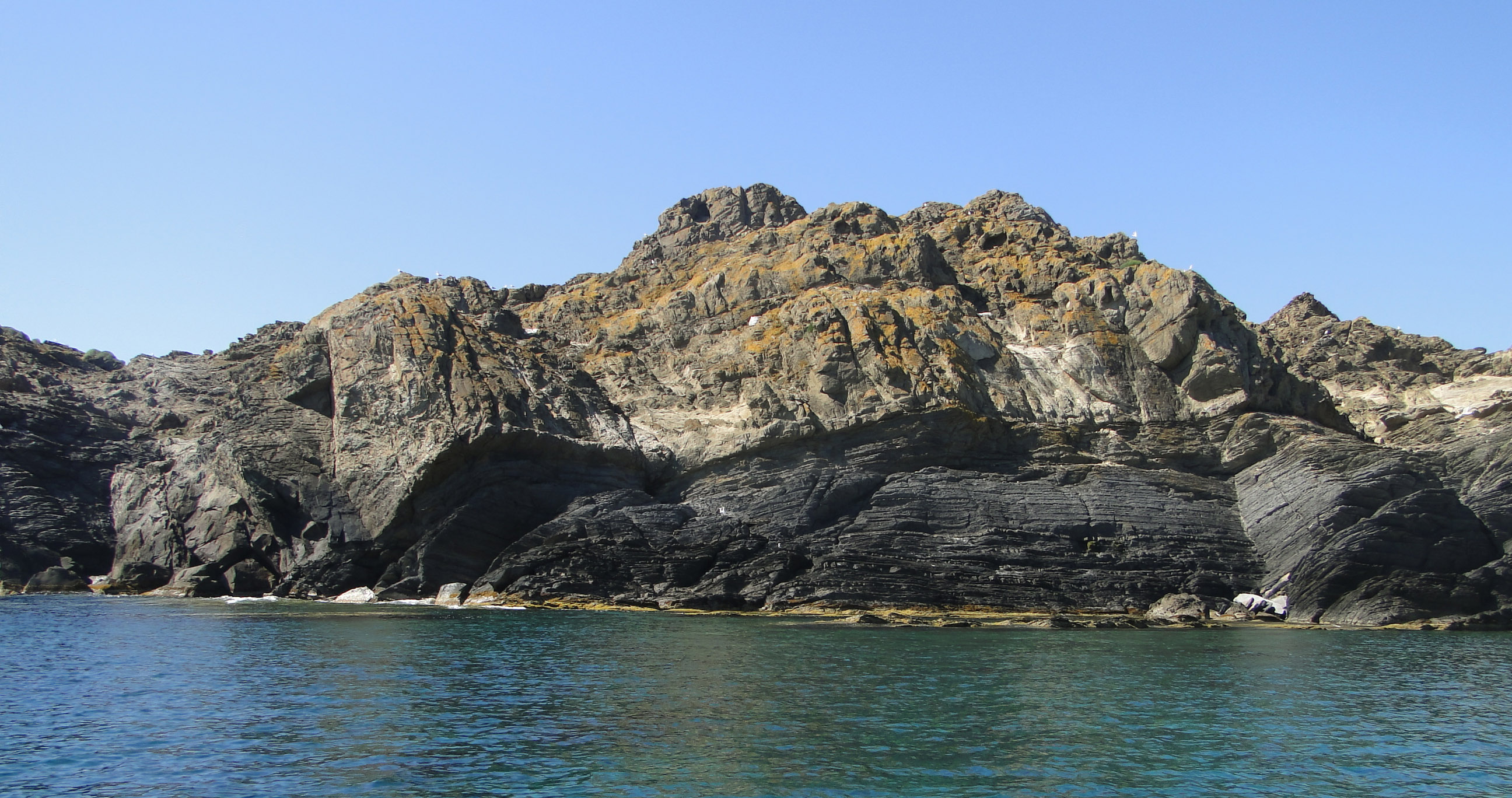
Bowl disjunction in the sandstone on Illa d’en Colom and S’Arenal d’en Moro beach with the llosella in the background that dominates its northern edge.