The lands of Macar de sa Llosa are a completely unique site in the geological context of Menorca. They correspond to a tectonic trench (or graben), an area that sank due to the action of faults, leading to an extensive depressed area. At the Site of Geological Interest, this tectonic trench was subsequently filled with sediments that would give rise to what we know as conglomerates and sedimentary rock formed by angular pebbles of a size greater than 2 mm and representing at least 50% of the total mass of the rock. The pebbles are united by a cemented material named matrix.</span></p></div>">breccia. These are sedimentary rocks formed predominantly by cobbles with a diameter of more than 2 mm: if these are rounded, they constitute sedimentary rock of detritic origin (clasts larger than 2 mm).</p></div>">conglomerate, whereas if they are angular they form sedimentary rock formed by angular pebbles of a size greater than 2 mm and representing at least 50% of the total mass of the rock. The pebbles are united by a cemented material named matrix.</span></p></div>">breccia.

Diagram of the formation of the tectonic trench at Macar de sa Llosa. The action of tectonic movements of distension caused the appearance of normal faults in Cretaceous and Jurassic rocks. These faults led to the earth collapsing, which would be filled by cobbles carried by violent streams at times of severe storms in the late Paleogene.
These cobbles came from the erosion of mountains made up of rocks typical of the Jurassic and Cretaceous periods. The mountains were eroded by highly energetic streams, that were short and strongly sloping, which subsequently deposited the cobbles at times of severe storms. In other words, as currently occurs in high mountain areas, downpours led to huge avenues of water, but also of sediments. Consequently, the depressed areas steadily filled up with the materials carried by the streams of the same composition as the surrounding rocks. The discovery of some fossils of algae (charophytes) among these rocks enabled us to determine that the sedimentation of these rocks occurred in the late Paleogene (around 23 million years ago), so representing the only known rocks in Menorca from this geological period.
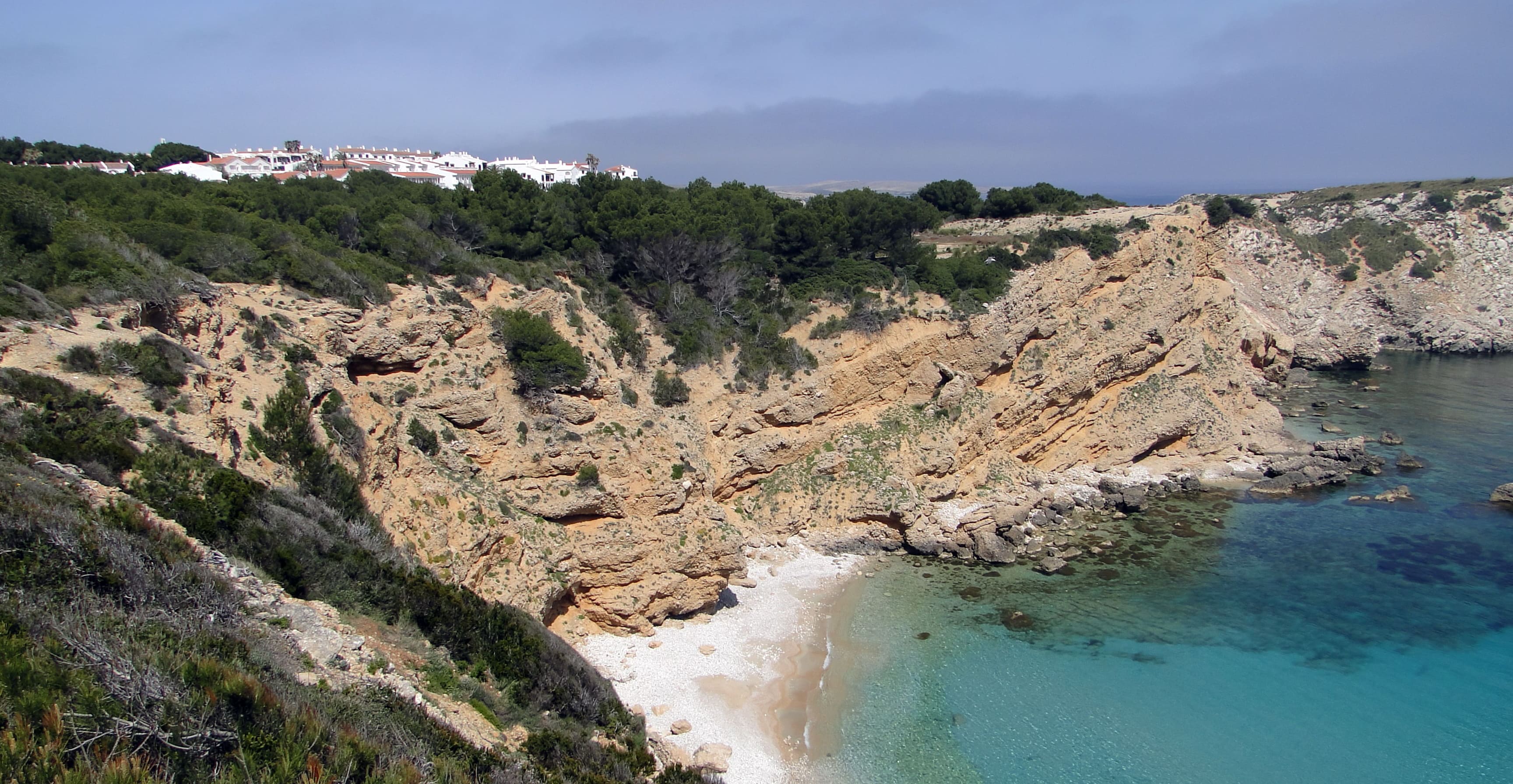
General view of Macar de sa Llosa. Inland, the shingle (or macar) becomes white sands of carbonate composition.
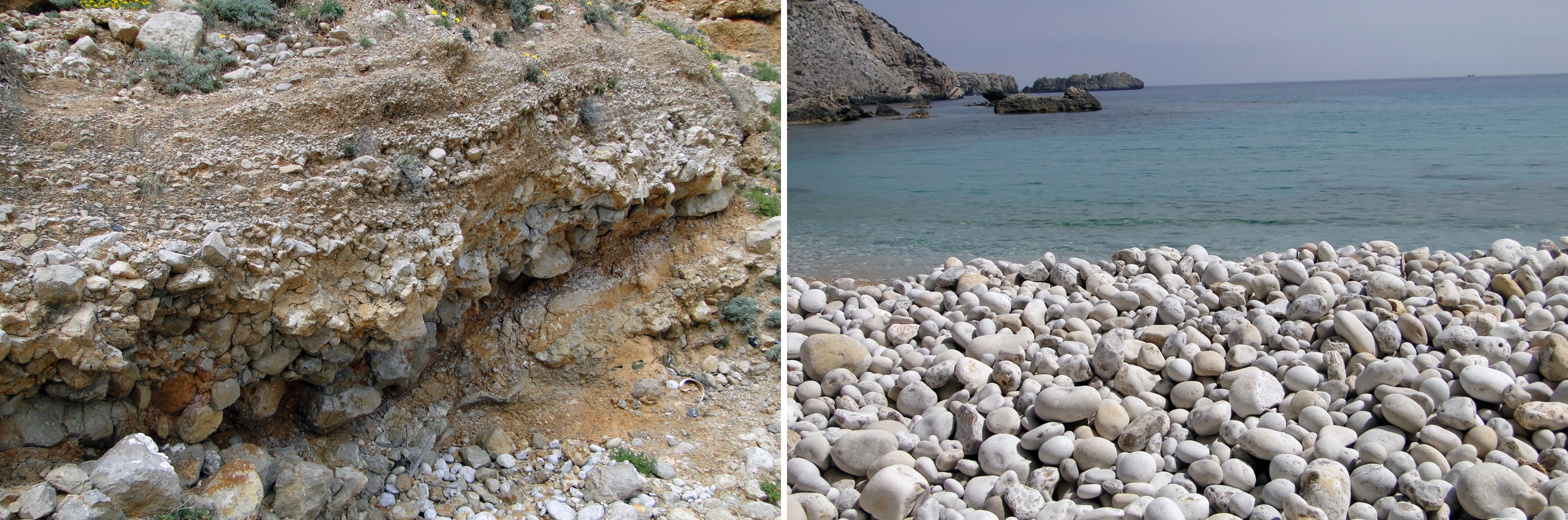
The fact that angular cobbles dominate the rounded ones indicates that the transport was very short, without giving enough time for them to become rounded and turn into pebbles. By contrast, the cobbles that have fallen from the cliff have been affected by the wear caused by the waves, which has given them rounded shapes, which is why they constitute a shingle (or macar). If the cobbles on the beach were angular, this would give rise to a rocky beach (or codolar).
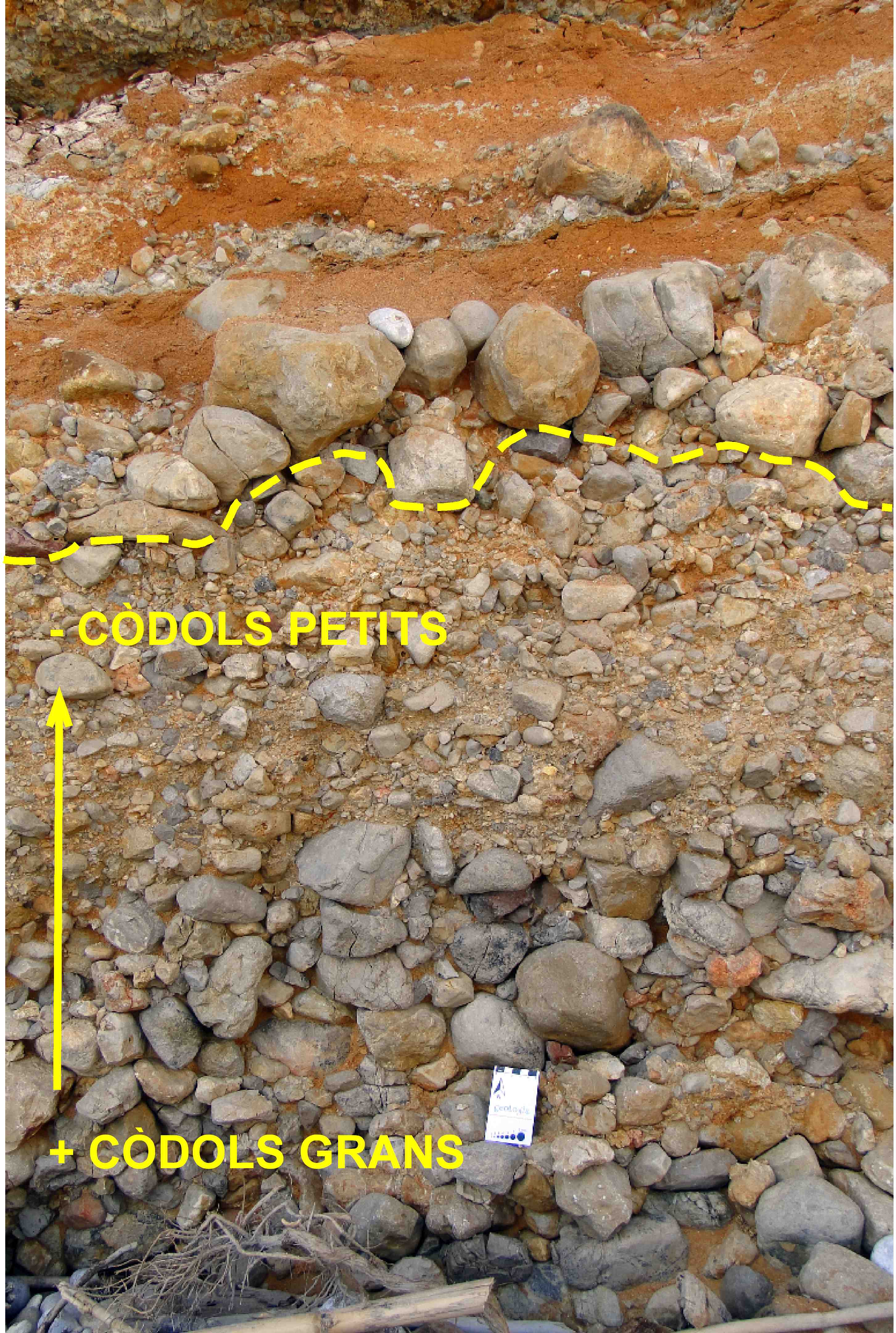
Each layer of conglomerates is the product of the sedimentation of a single avenue as a result of a severe storm. The dotted line indicates the separation between two different avenues. Usually, the cobbles are scarcely ordered, as the transport was too short and they did not have time to get organised, although sometimes, like in the picture, they are graded, in other words, the biggest ones are at the bottom, and they slowly become smaller towards the top
Among the conglomerates, we can identify numerous layers of red clays that may be from channel overflow sediments. In other words, they are smaller particles (clay) that were also transported by these streams and that only sedimented when the water was completely stopped after the overflow of the channel. In these clays, we can identify small nodules of caliche, occasionally forming a small crust, characteristic of the soils of arid and semi-arid areas, which forms one or more layers on the calcic horizon of Sedimentary rock whose main component is calcium carbonate (CaCO3). Its origin can be chemical, organic or detritic.</p><p><br></p></div>">limestone soils. These nodules indicate a sedimentary stop that was long enough for soil to be formed. Occasionally, the clays adopt a violet colouring that can be related to the clay sedimented in a small, sporadic lacustrine (relating to lakes) basin, which also indicates times when no sedimentation occurred.
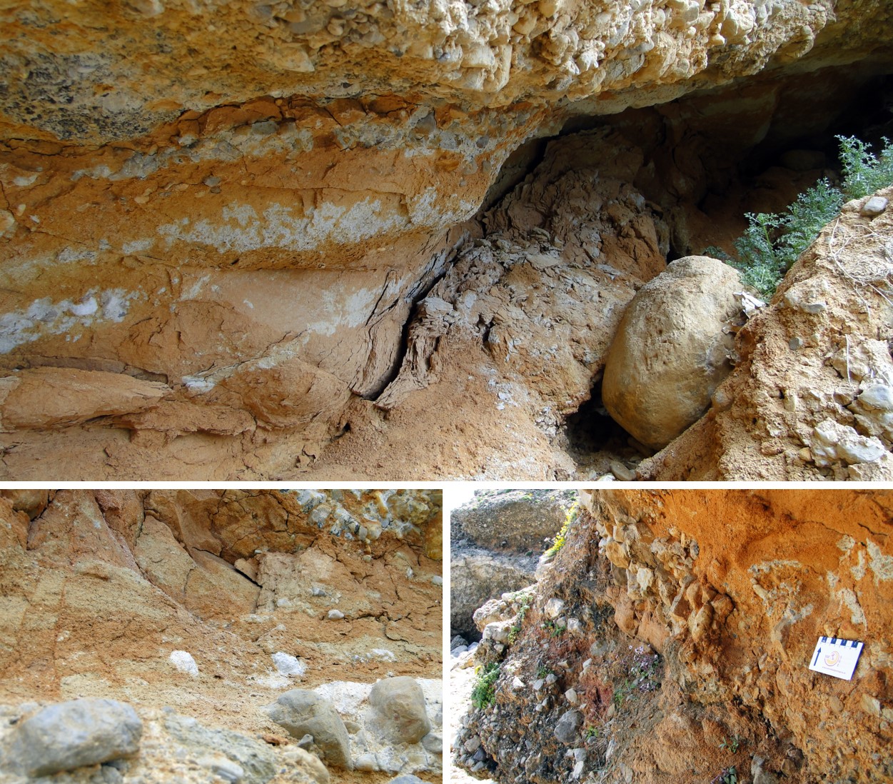
Example of clays caused by the overflow of streams, close-up of white caliche nodules and comparison between typical tile-coloured overflow clays (in the foreground) and those that may correspond to wine-coloured lacustrine basins (at the back and higher up).
Therefore, the sedimentation of conglomerates and sedimentary rock formed by angular pebbles of a size greater than 2 mm and representing at least 50% of the total mass of the rock. The pebbles are united by a cemented material named matrix.</span></p></div>">breccia is very fast, but between the formation of one layer and another, a fairly long period of time might go by of tens, hundreds and even thousands of years where there is no sedimentation and that allows soils to be developed. However, as a whole, the filling of these depressions is usually short, in terms of geological time, that is. Once the trench is refilled and levelled with the surrounding relief, the streams no longer have the ability to erode, transport and, consequently, sediment materials.
The tectonic trench is bordered to the south by Jurassic dolomite cliffs that go as far as S’Arenal d’en Castell, which have been greatly eroded and form a practically flat surface, and to the north by the limestones and marls of Cap des Redoble headland, sedimented during the lower Cretaceous and that also makes up a large part of the eastern side of La Mola de Fornells mesa. The existence of the only nearby cretaceous outcrops leads us to believe that the source area where these sediments came from was to the northwest of the present tectonic, eustatic or antropical processes</span></p></div>">outcrop. Probably the fault was active and, therefore, moved while the sedimentation of the conglomerates and sedimentary rock formed by angular pebbles of a size greater than 2 mm and representing at least 50% of the total mass of the rock. The pebbles are united by a cemented material named matrix.</span></p></div>">breccia occurred.
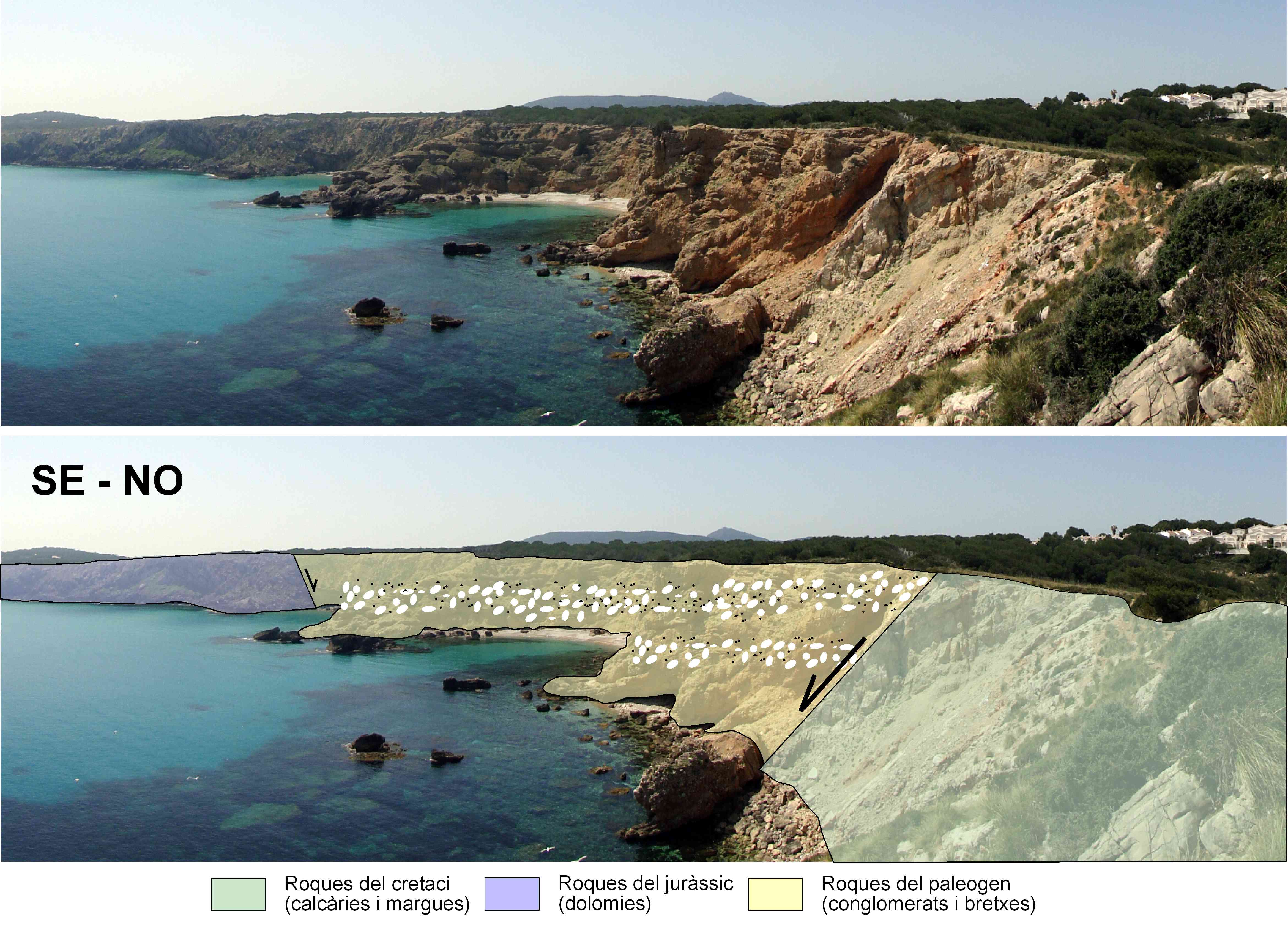
Geological layout of Macar de sa Llosa from the southeast (left) to the northwest (right). The Cretaceous limestones to the north and the Jurassic dolomites to the south demarcate the tectonic trench, which sank and later filled with conglomerates and breccia.
The outcrops of the lower Cretaceous, very much reduced in extent in Menorca, are made up of very fine-grained limestones where there are sometimes abundant remains of small fossils of echinoderms, gastropods and mollusc with a body protected laterally by a shell composed of two pieces or valves, generally symmetrical in a bilateral plane<strong>.</strong></p></div>">bivalve molluscs. This geological series is also made up of grey and sometimes yellow marls that, at the top of the series, can display frequently limonitised fossils of ammonites.
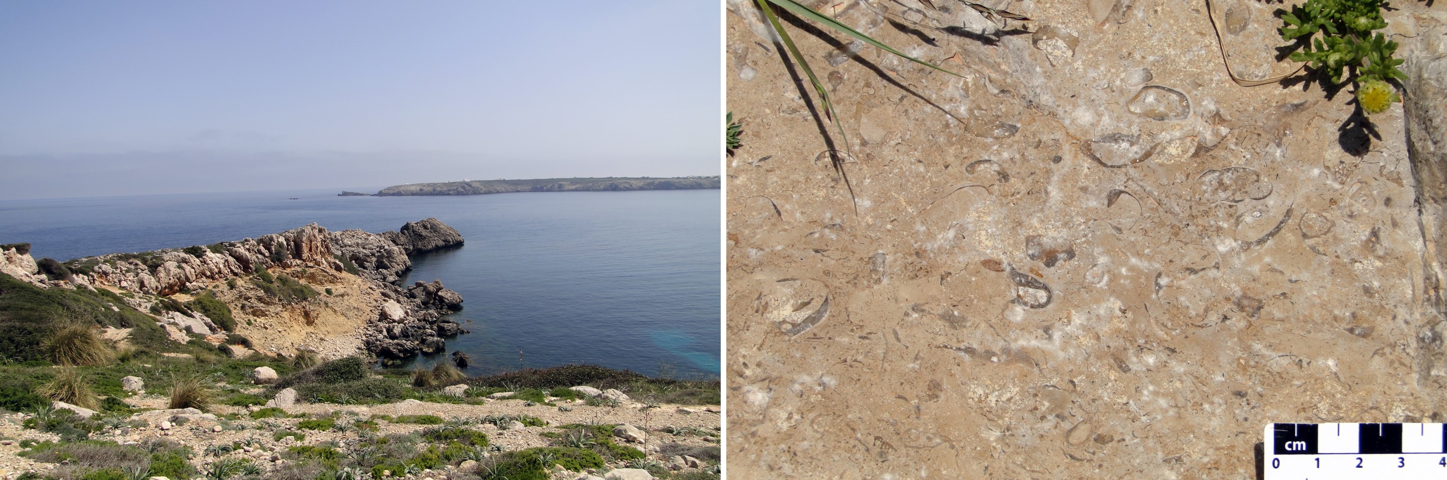
Cretaceous rocks at Cap des Redoble headland and close-up of the fossils that can be identified in these rocks.