The site runs along the southern edge of tall coastline at Ciutadella, including the coves in this stretch and the cliffs surrounding them. Its beauty is down to the processes and resulting forms that have modelled the coastline and in particular the coves. The Talaia d’Artrutx tower, on the western edge of Cala en Turqueta, is where the coastline begins to rise gradually eastwards (interrupted in the depression that created the Albufera de Son Bou lagoon) and the succession of Menorca’s most distinctive coves, opened in the final section of streams set in deep ravines.
The coves are where the sea has penetrated inland, usually following an ancient river mouth, and where the rocks that line its banks have been affected by the processes of, among others, marine and karst erosion, and where there is always a great variety between the rocks. The mechanisms that created the coves are associated primarily with the dissolving of Sedimentary rock whose main component is calcium carbonate (CaCO3). Its origin can be chemical, organic or detritic.</p><p><br></p></div>">limestone (karstification) and the orientation of the large fractures that affect the rock, marine dynamics and the route of the river itself.
The role of fracturing is essential in understanding how coves are formed. When the rock breaks and a fracture opens up, it creates an area of weakness that is used by surface water currents to pass their flood system through. Fractures follow more or less straight lines and so may create a linear component in the course that the streams follow. This influence can be seen in the Cala en Turqueta ravine, with tributaries perpendicular to the main ravine due to the effect of the fractures, and also at Cala Macarella. Here, the mouth of two ravines form a cove with two branches, the Macarella and Macarelleta inlets, which are also defined by the fractures. The Santa Anna ravine, which empties into Cala Macarella beach, follows a fracture running approximately north to south, while the much smaller Macarelleta ravine, runs in another direction from east to west.
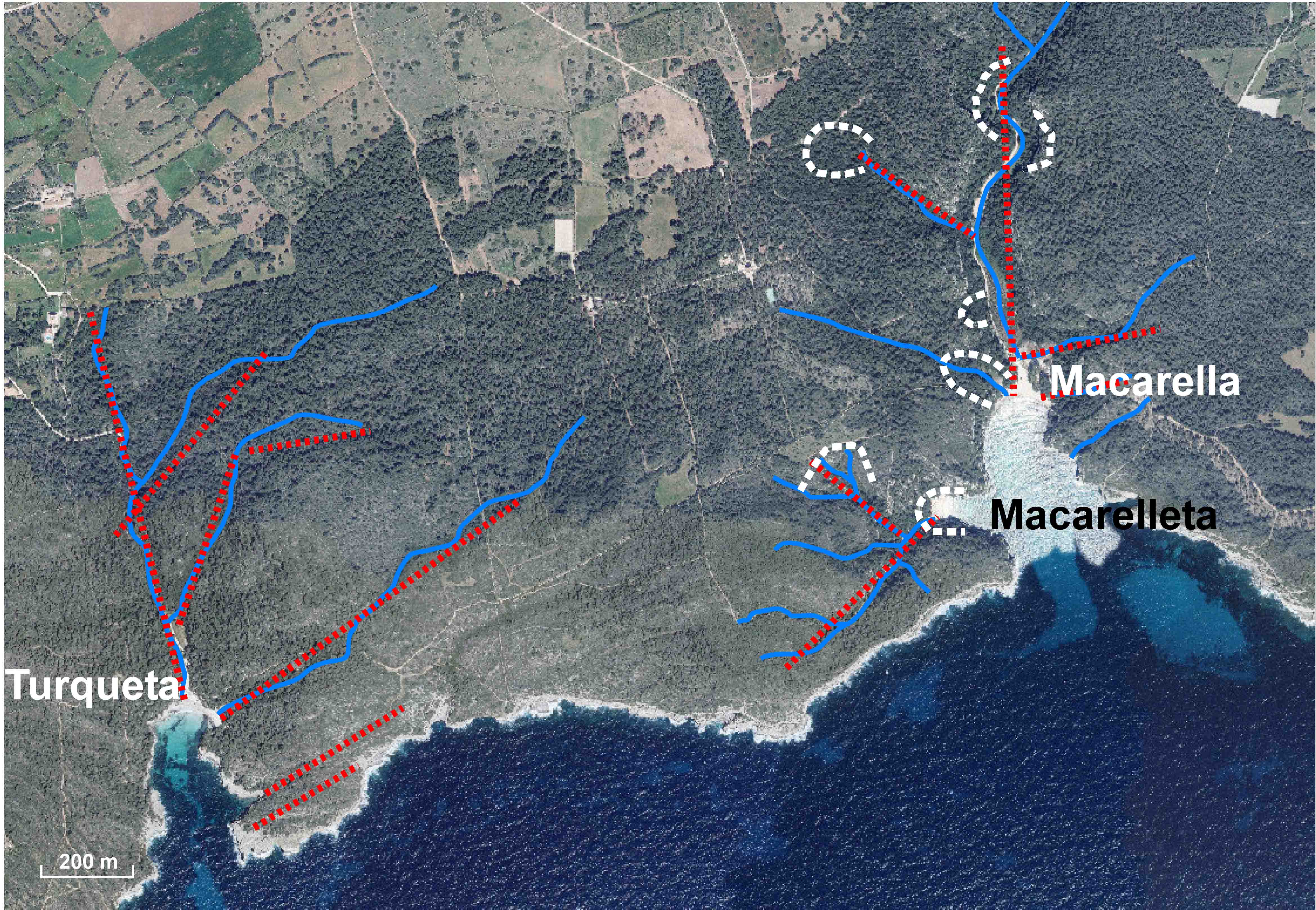
Course of the main streams (in blue) that flow into Cala en Turqueta, Cala Macarella and Cala Macarelleta The route of the streams is highly influenced by the main fractures (in red) that affect the rock. The main collapses (swept sink holes), which were key to the creation of the coves and the configuration of the ravines with the appearance of “false” meanders, are shown in white.
The creation of the coves would not have been possible without the falls in sea level that occurred worldwide due to glaciations, which held most of the Earth’s water as ice at the geographical poles and on the peaks of its mountains, which led to this global fall in levels. If sea levels drop, rivers become steeper and in effect their erosive power increases significantly. This caused rivers to narrow and create deep canyons, such as the ravines, that would trigger significant instabilities. In turn, falls in sea level mean that the underground water levels also fall, leading to the collapse of rock masses that were “supported” by this water.
In any event, the morphologies that dominate this stretch of coastline would not have been possible without the erosion and corrosion resulting from the dissolving of Sedimentary rock whose main component is calcium carbonate (CaCO3). Its origin can be chemical, organic or detritic.</p><p><br></p></div>">limestone, karstification. Karst refers to the processes that lead to a series of specific forms in terrain comprised of rock with high levels of solubility (such as Sedimentary rock whose main component is calcium carbonate (CaCO3). Its origin can be chemical, organic or detritic.</p><p><br></p></div>">limestone) and porosity. Consequently, we should stress that karstification is possible as it usually acts when there are numerous fractures present, which makes the rock more porous and allows the water that causes the dissolution to run off and the fractures then expand. We should also highlight that the caves on the coastline, which are a very common occurrence, are formed largely through the interaction of underground freshwater and salt water that has also penetrated the rock. The mix of the two waters, of quite different chemical compositions, means that they become much more aggressive and so increase the dissolving of the rock with the creation of large cavities.
The dissolving of the rocks will end up enlarging the caves to the point where they can no longer bear the weight of the land on top of them and they collapse. The falling of rocks from the cliffs leads to their retreating, and to the formation of the coves. Cala Galdana is a good example of this process. It is clearly circular or elliptical in shape and demarcated by vertical walls that present a number of concave curvatures. These inlets that surround the cove in an irregular pattern are where fractures were created by water run-offs, which then expanded the fractures by dissolving the rock. This process led to the ground collapsing. Concave inlets, resulting from karst collapsing, are also frequently found in ravines and responsible for widening them.
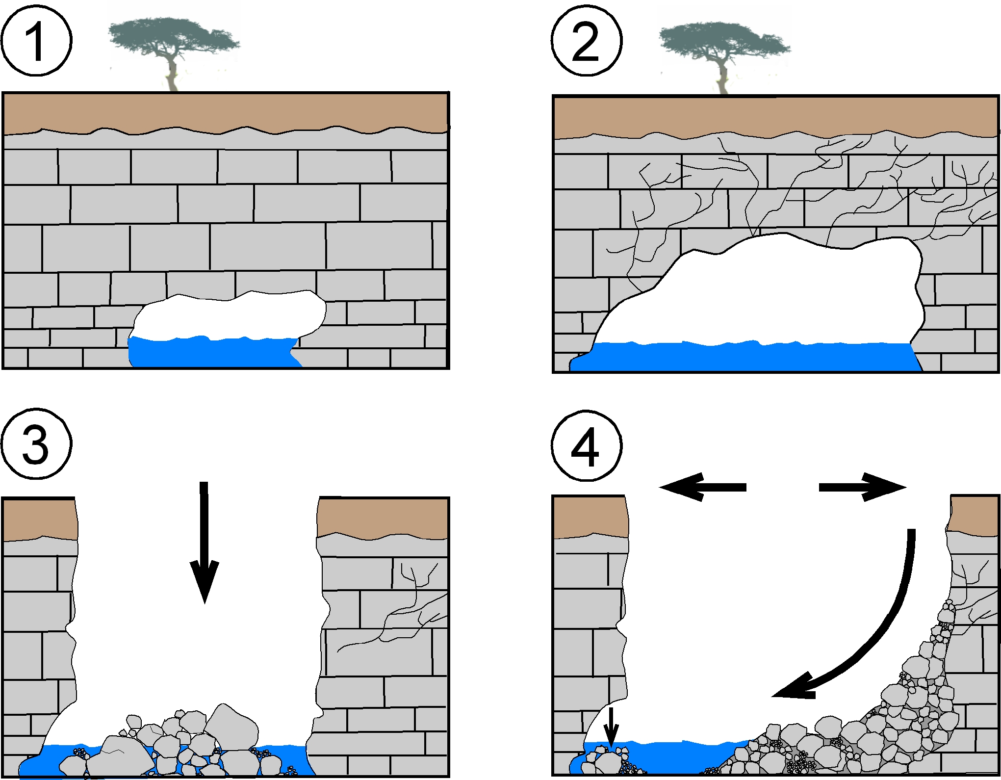
The coves that make up the site were created following a succession of collapses, usually associated with the presence of caves and galleries, linked to fractures. These cavities would have been opened up when Sedimentary rock whose main component is calcium carbonate (CaCO3). Its origin can be chemical, organic or detritic.</p><p><br></p></div>">limestone was dissolved by underground water that often became more aggressive when interacting with sea water (1). The fact of the cave growing (2) would have caused fissures and the sinking or collapsing of its ceiling (3) when it could no longer support the weight of the Sedimentary rock whose main component is calcium carbonate (CaCO3). Its origin can be chemical, organic or detritic.</p><p><br></p></div>">limestone. This would then create a depression in the vertical walls that, over time, would expand due to blocks falling and slipping (4).
Along the cliffs lining the coves, we often see caves that are linked to the same processes that created the coves, but are logically less developed. The caves are the outflows of underground conduits opened up by dissolution from underground water (with more or less help from sea water) and linked to vertical fractures, which are weak spots in the rock, that gives them an elongated shape.
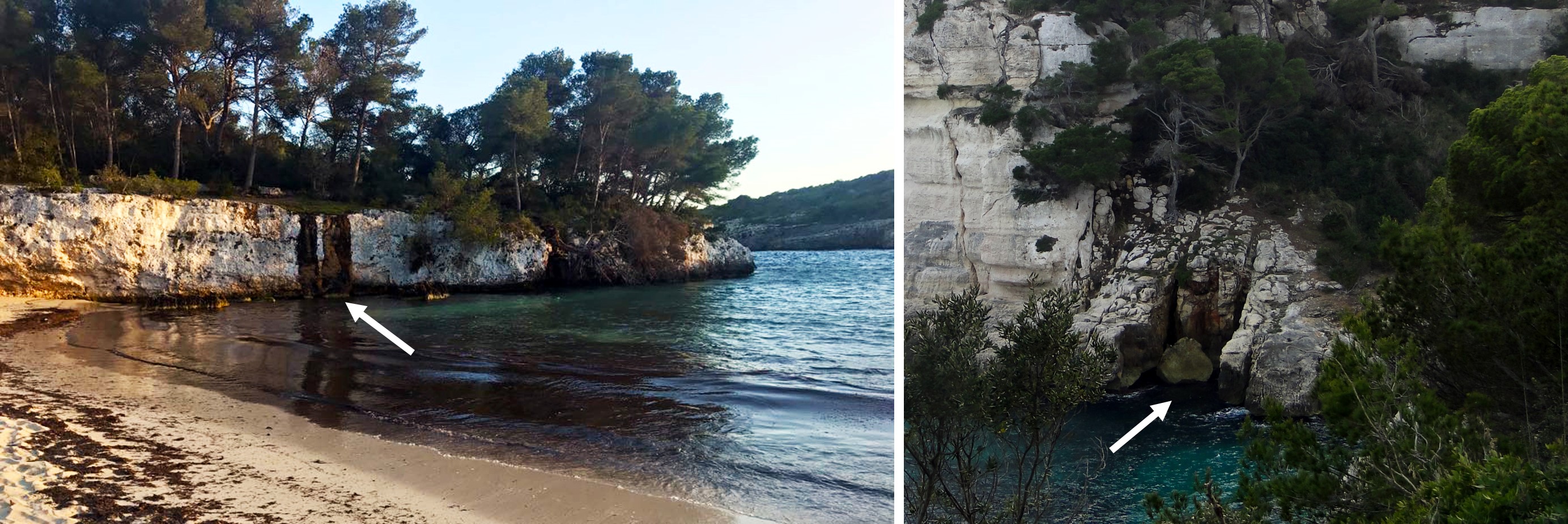
Conduits created by dissolution from underground water at Cala en Turqueta and the western edge of Cala Galdana, linked to vertical fractures.
So, the coves that make up the Site of Geological Interest and the many morphologies that comprise its cliffs (but which are much less developed) are the result of the layout of the flood system, which followed preferred routes according to pre-existing fractures during the last glaciation, which began around 110,000 years ago. The fall in sea level led to the collapse of cavities and the acceleration of the processes that dismantled the cavities and underground conduits.
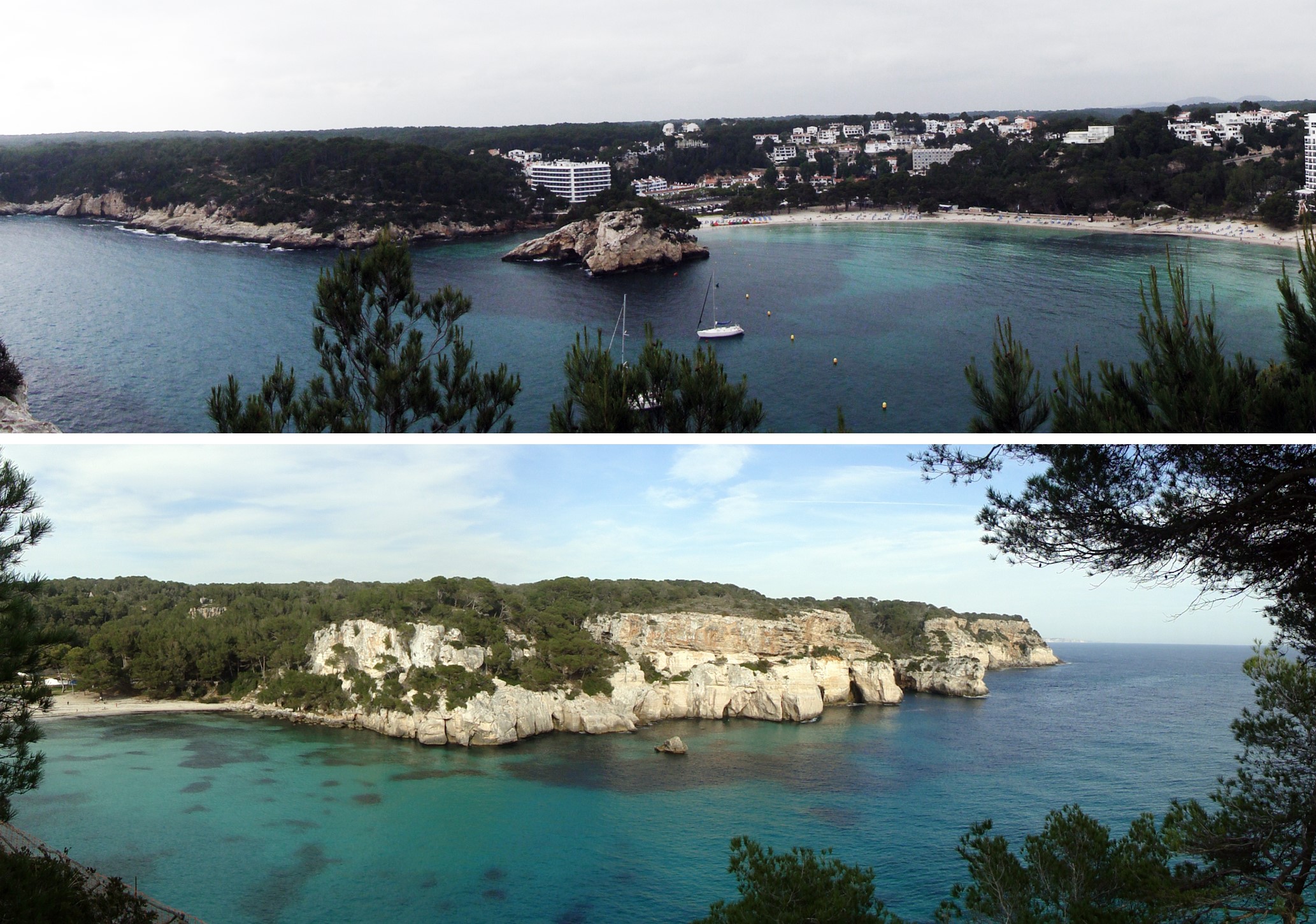
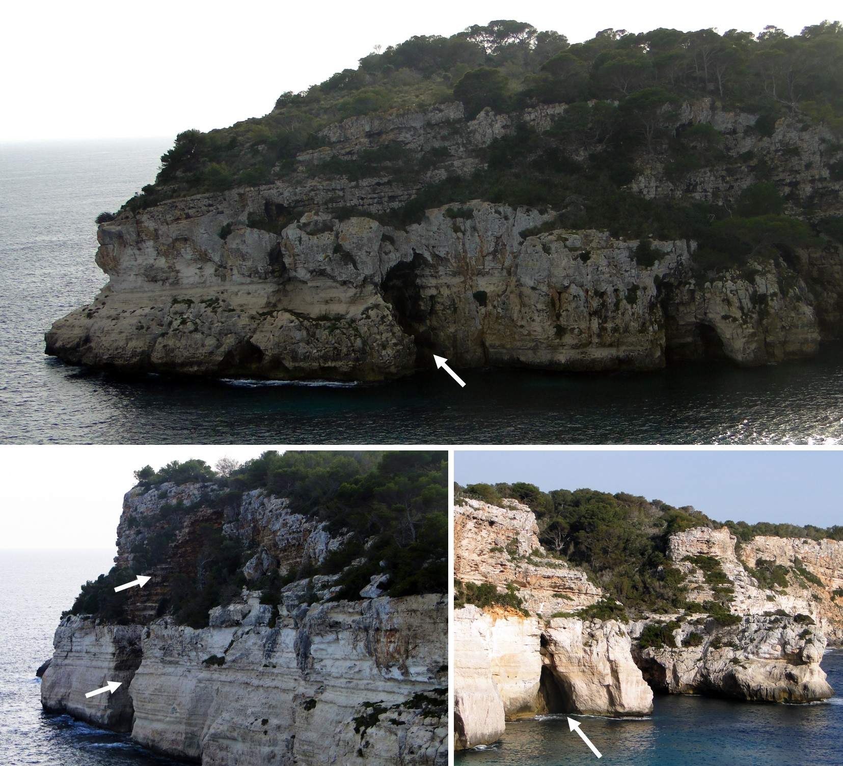
Panoramic views of Cala Galdana and Cala Macarella where you can see numerous cavities and concave forms on the cliffs linked to karst collapses.
The subsequent rise in sea levels resulted in the invasion of areas that were more widely excavated at the time the streams were formed. This rise in sea level led to the creation of an estuary and filling that would refill sediment until its current layout was completed. This way, the last part of the ravine and therefore the part closest to the coves has filled with marine sediments and from the lagoons. The deposits created by this refill are up to 20 metres thick at Cala Galdana.
We should also mention that at the Place of Geological Interest, remains of fossil dunes have been discovered, which were used in the Maresos de Sa Marjal and Alparico quarries, where traces of fossils (ichnofossils) have been identified and where at Macarella they form a deposit of about 4 metres deep at the western edge of the beach. At Cala Galdana, these rocks form two separate sites. Finally, we should point out the geological variety of different outcrops of the coastal detachments, which clearly show the separation between the two upper and main units described during the Menorcan Miocene.
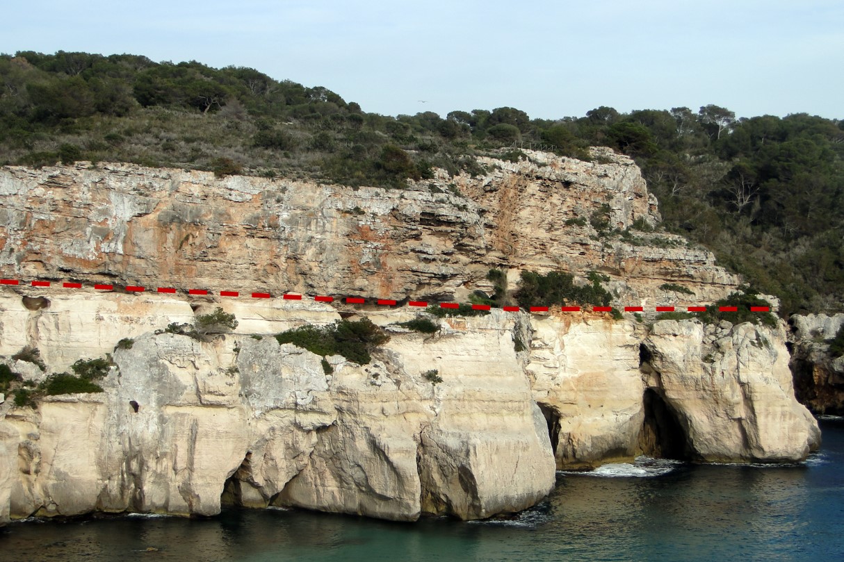
Varieties of rock at the Site of Geological Interest, where you can see two different geological units. The upper unit sedimented around 11 million years ago in a flat and inclined area towards the sea depths, at different depths, while the upper unit would have been deposited around 7 million years ago in a reef environment.