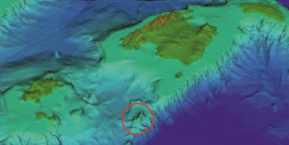
As is well known, the Balearics are not volcanic islands, but close to them, on the south-eastern slope of the Balearic Promontory (the continental platform that supports the entire archipelago underneath the sea) there is a relatively recent volcanic zone. It is named Émile Baudot Volcanic Field and is also known as the South-East Volcanic Province.
Location of Émile Baudot Volcanic Field within the Balearic Promontory. (GRC Marine Geosciences, Geology Faculty, UB).
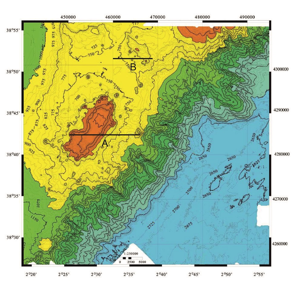
Relief of the Émile Baudot Seamount and Scarp zone. The profiles ‘A’ and ‘B’ have their correspondence in the following figure. (Acosta et al, 2001)
It is located some 70 km south-east of the island of Cabrera, at the south-eastern end of the Mallorca’s Channel, and consists of more than 80 volcanoes.
Its most notable relief is the Émile Baudot Seamount, 3 km wide, 10 km long and with table-like morphology, the summit of which is at less than 100 m depth. It corresponds to a class of flat-topped volcanoes called guyots.
In its south-western flank there is the Émile Baudot Escarpment, an immense cliff some 2,000 metres in height that separates the Balearic Promontory from the Algeria Basin.
The origin of this volcanic region is related with the tectonic activity of the faults which divide the Balearic Promontory, one of which is located between the islands of Mallorca and Eivissa.
The age of the magmatic intrusions is from the Upper Miocene (Tertiary), since they affect sediments of this period and are in turn covered by sediments of the Pliocene (Tertiary) and the Quaternary. During the desiccation of the Mediterranean (approximately 5.5 Ma ago), the volcanic field lay above the sea level, suffering erosion and acquiring the guyot morphology observed today.
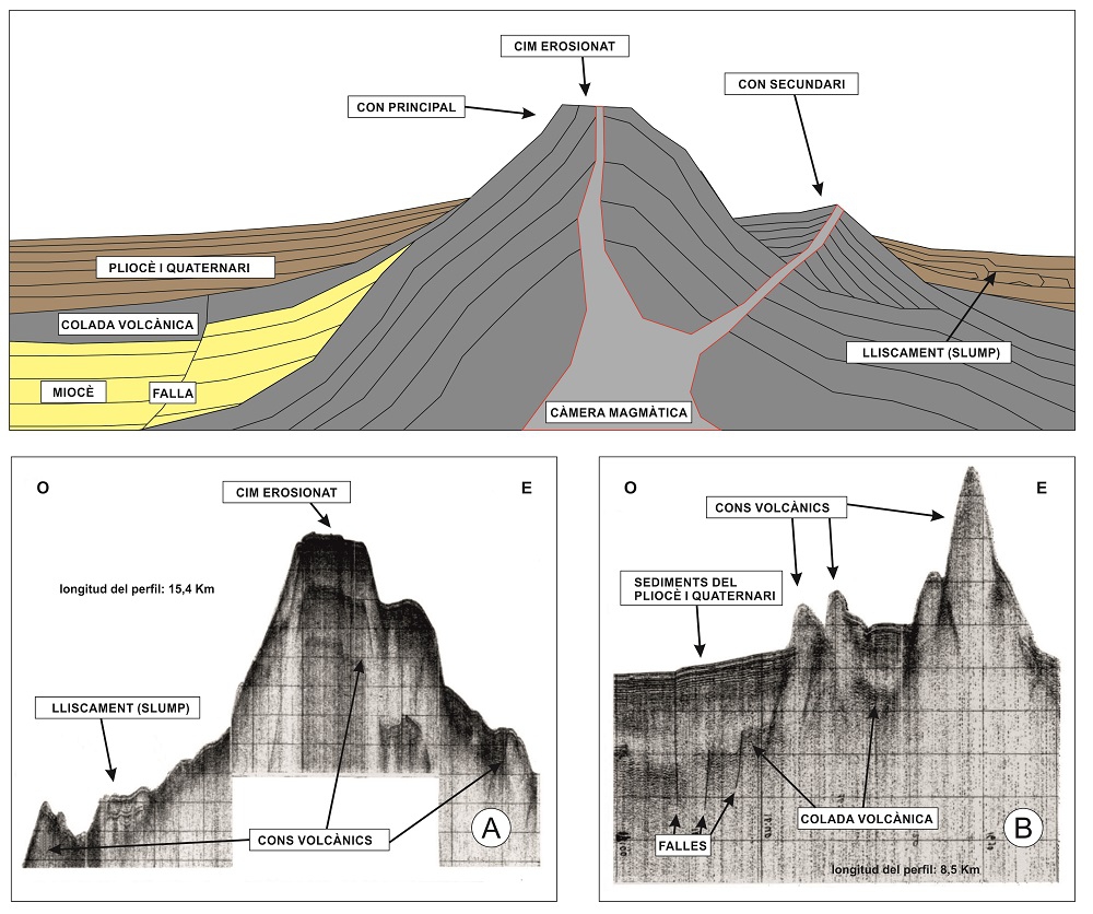
Idealised diagram with the principal geological features of the Émile Baudot Seamount (above) and two seismic profiles of the seamount and its surroundings (below), corresponding to those indicated in the previous figure as ‘A’ and ‘B’.
When the Atlantic invaded the Mediterranean again, 5.3 Ma ago, the zone was submerged and was gradually covered by sediments of the Pliocene until the present day. Throughout all this time the Émile Baudot Field has been affected by normal faults and large-scale submarine landslides (slumps), which are observable in the seismic profiles.
The last time the summit of the principal volcano was above sea level must have been during the last Ice Age, when the ice accumulated at the poles caused a lowering of the sea level great enough to connect Mallorca and Menorca by land.
Since the volcanic field is submerged, in order to determine its geological characteristics it has been necessary to use geophysical prospection, a research method based on the physical properties of the materials of the Earth.
In this case, a technique called acoustic or seismic stratigraphy has been used. This consists in projecting shock waves against the seabed and measuring with sensors their response time in relation with the distance covered. This indicates the density and distribution of the materials of the subsoil, and computer programs can then reconstruct its profile after processing the data.
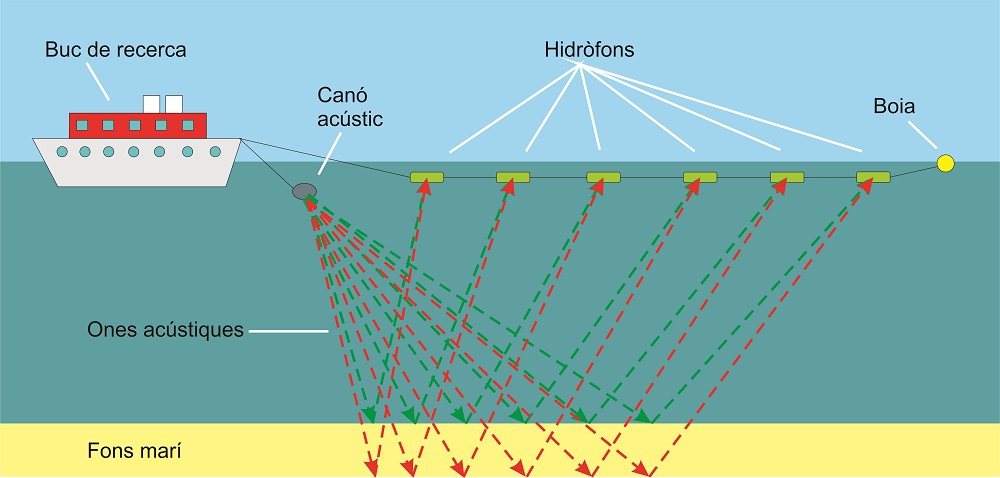
Functioning of the acoustic stratigraphy technique to determine the geology of the seabed