The Algendar ravine is one of Menorca’s most characteristic and unique settings. It begins in the Tramuntana region, is 8.5 kilometres long from the Puig de Santa Magdalena hill down to Cala Galdana with an almost rectilinear path and comprises deep fluvial canyons, with practically vertical walls cut into the Miocene marès and inclines of around one hundred metres. Although it has an overall direction, the ravine describes numerous twists and turns, displaying a very long fluvial section of between 50 and 100 metres wide, with vertical walls in several sections of an average height of 50 metres and a maximum of nearly 80 metres.
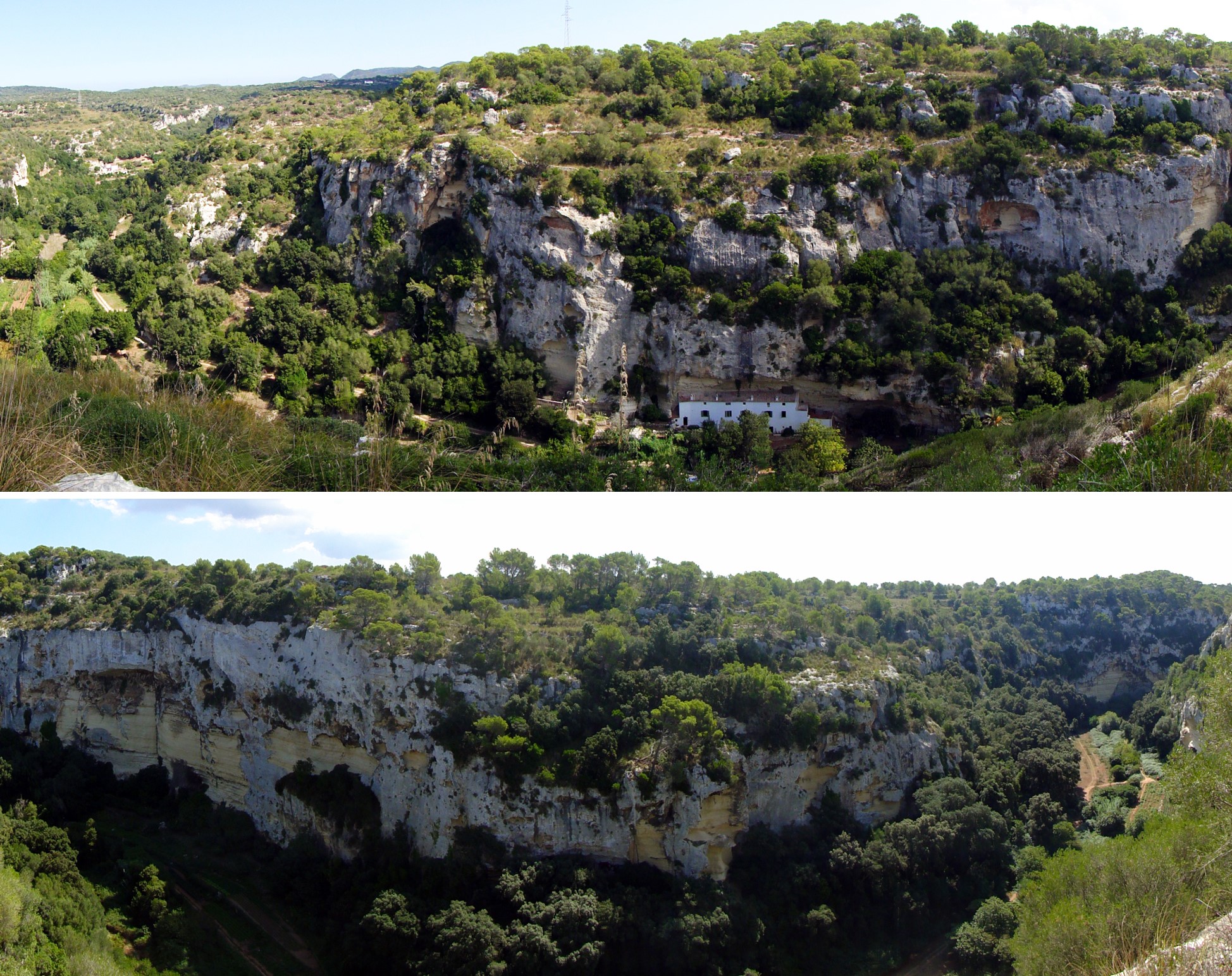
Panoramic views of the Barranc d’Algendar ravine. The top photograph shows the Molí de Baix houses, which are embedded in the cliff and where a cave has been used to build them in an area where the cliff is more eroded at the bottom than at the top. The bottom photograph shows the ravine’s winding route. The numerous twists and turns described by the ravine are largely due to the ground collapsing. Subterranean water dissolving the rock can cause the cave ceiling to collapse, forming circular depressions of varying sizes known as sinkholes, which occurred on the sides of the ravine, so widening its river bed.
The stream that currently flows through the Algendar ravine has water all year round. This is because it is supplied with subterranean water from the Migjorn aquifer (despite its levels dropping considerably in recent decades) that literally spring up at numerous points along the river bed. Remember that a ravine is a sharp incline in the land surface, which is usually due to erosion caused by a river. If the incline is sufficient to intercept the Top level of subterranean water where the hydraulic pressure is equal to the atmospheric pressure.</p><p><br></p></div>">water table (the upper part of the aquifer) it will supply the stream with water. When this interception occurs above the lamina of water carried by the stream, the water may appear as springs.
The Algendar ravine has the most springs of all Menorca’s ravines. There are currently 10 springs with water, with a greater or lesser flow, and records show that at least 6 have stopped gushing, all of which are in the upper reaches of the ravine. From the Puig de Santa Magdalena to Pla de Son Pruna there are no signs of water springs. Drainage in the upper part of the ravine is through the S’Aranjassa spring (recovered in 2014 thanks to an ecological agricultural project run by Caritas Diocesana), the Son Pruna and Sobrevell springs and the Sa Dragonera spring, which is the only one in this section of the ravine that maintains a considerable flow. In the middle section, the stream is fed exclusively by the Torre Petxina spring, while the lower section contains two important springs: the Son Fonoll and Els Eucaliptus o Desmais springs, which is the most popular in this Site of Geological Interest where the outflows of water from the aquifer flood the land around the stream.
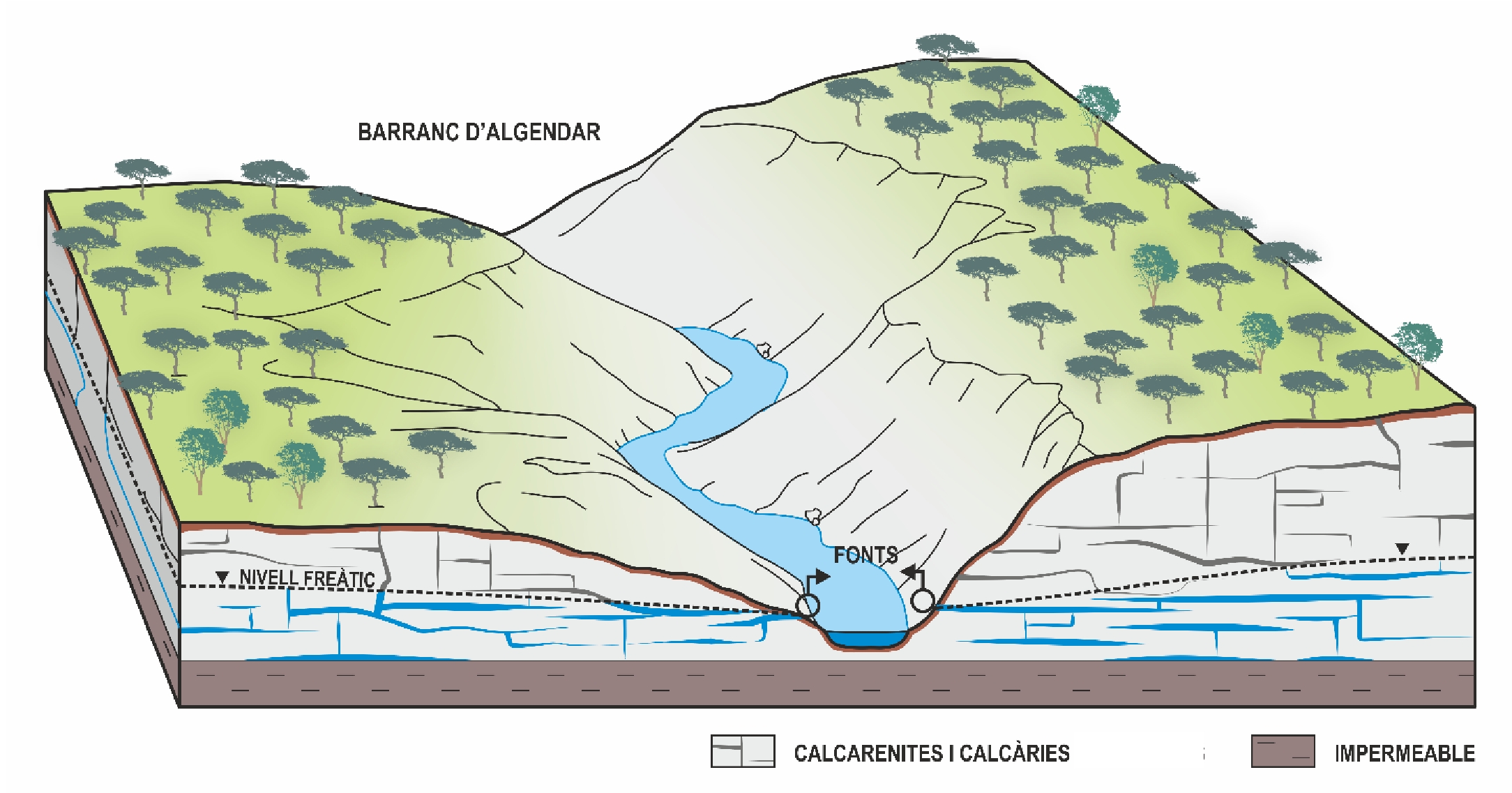
Block diagram representing the Barranc d’Algendar ravine. Excavation by the ravine causes the water table to intersect with the topographical surface and makes it possible for upwellings of freshwater to appear.
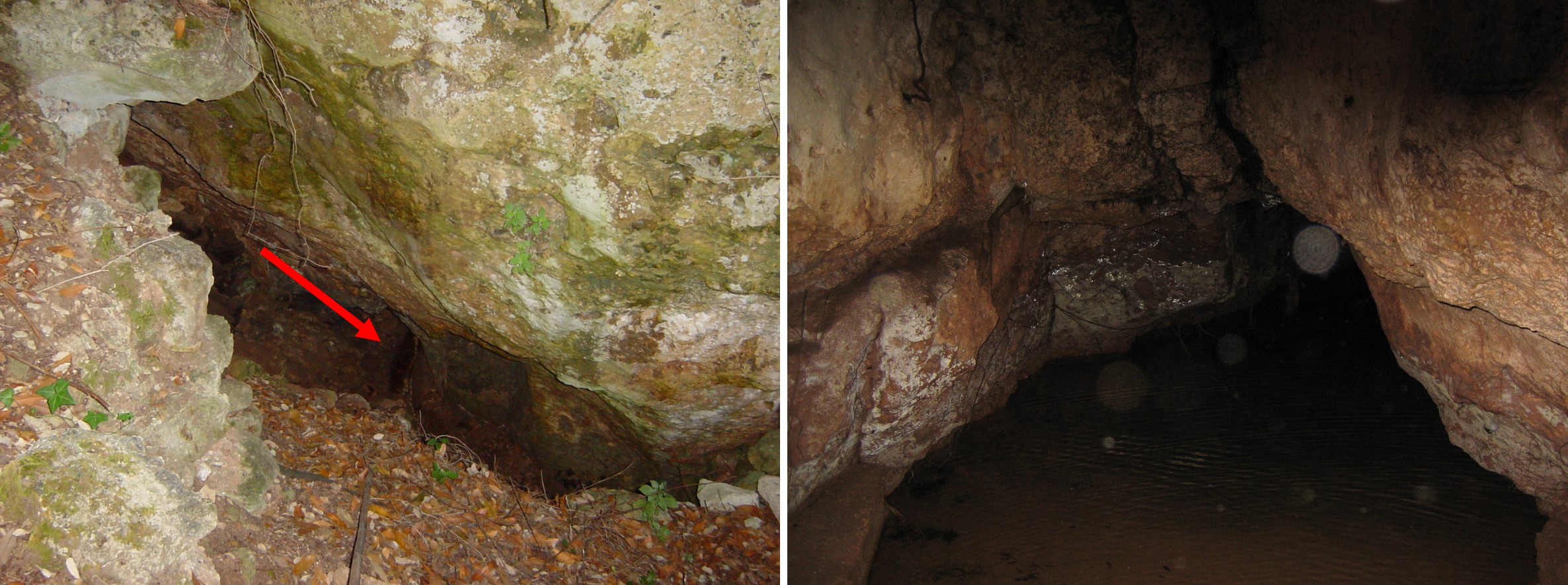
Sa Dragonera and Son Fonoll springs. The arrow indicates the small channel through which the water flows out of the Sa Dragonera spring. The Son Fonoll spring is the spring with the largest flow in the Algendar ravine. It develops in a considerably large cavity and supplies water to the Cala Galdana and Serpentona residential areas, together with various wells. In times of considerable rainfall, the water supply to the residential areas has to be shut off because it turns reddish from the clays swept along in it.
In terms of geological material, the huge vertical ravine walls are made up of a homogeneous series of marès containing fossils, particularly sea urchins, and bioturbation, in which the hardest Sedimentary rock whose main component is calcium carbonate (CaCO3). Its origin can be chemical, organic or detritic.</p><p><br></p></div>">limestone sections can be identified. In its final section, the ravine displays a silt and sand filling from the Holocene (the most recent geological era) of up to 20 metres thick.
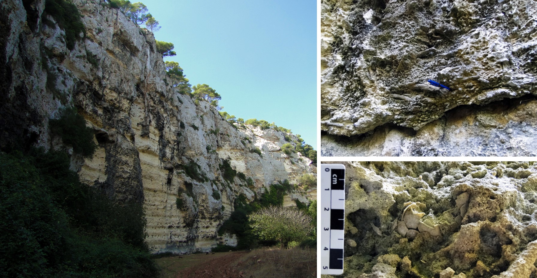
Towering walls along the Trencada de Son Fonoll and close-up of bioturbation (changes to the sediment caused by the action of organisms) and the fossil of a sea urchin in the ravine.
These deep ravines are only found in the central part of Menorca’s Migjorn region. This is because the region is slightly convex due to the action of tectonic movements, with maximum rising in this central part (area with the most curvature), forming what in geology is known as an anticlinal structure. Associated with the rising of this central part is the appearance of a series of fractures, which, as they are in the weakest areas of the rock, would be used by the streams to establish themselves and affect the Tramuntana area. As well as all these tectonic movements, we should remember the drops in sea levels that occurred worldwide during the Quaternary, which led to a rise in the slope and consequently gave the streams great erosive power sweeping and dragging rocks and sediments towards the sea. A later rise in sea levels some 10,000 years ago stopped and reversed this process, in other words, it created the stream’s generalised sedimentation in its lower reaches and filled the coves with sediments.
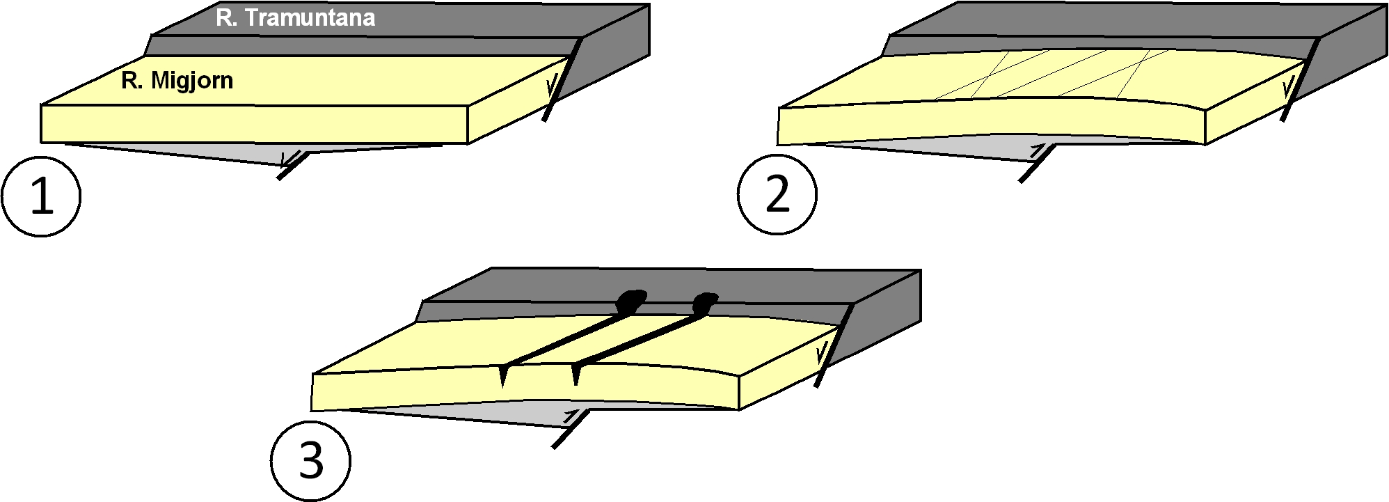
Evolution of the Migjorn region that would lead to the formation of the deep ravines in its central area. Marine sedimentation in the Migjorn region during the Miocene was created by its sinking compared with the Tramuntana (1). In the late Neogene – early Quaternary, the region gently folded, favouring the appearance of fractures in the area with the greatest curvature (central area of the region) (2). These fractures were used by the drainage system due to their layout, which even went as far as the Tramuntana area, so favouring their incision to create a larger area and the formation of the deep ravines at a time when sea levels were lower (3) (modified from Gelabert et al., 2005).
On the cliff faces of the ravine, notice the presence of different cavities of interest. For example, the Cova d'en Curt at the Binimassó ravine, a tributary of the Algendar ravine, comprises two very different parts: a very steep ground floor littered with large blocks and a horizontal gallery measuring over 332 metres and occupied by a brook, which means that this cave is still opening. We should also mention the Cova de ses Abelles, a non-functional gallery measuring 345 metres and an incline of only 14 metres but of greatly varying width, which looks as if it is hanging from an escarpment on the eastern edge of the Algendar ravine. It displays a zig-zag route, which tells us that its formation can be related to different fractures as opposed to water circulation. The Cova Murada is probably one of the most popular caves in the ravine and comprises a practically horizontal gallery that forms a series of highly-variable bends and is situated on the western edge of the Algendar ravine near Torre Petxina with an important but seriously plundered archaeological site.