Of all the caves in the archipelago of Cabrera, Sa Cova Blava is the best known, because it is the only one that can be accessed by the tourists who visit the Park, being a habitual stop for the ferries that carry visitors.
Its name is due to the turquoise colour of the waters of the cave when the sunlight shines on them.
This is a littoral cave with a clear structural influence. This type of caves originate from tectonic structures (folds or faults), which favour differential erosion. For this reason, its walls or ceilings correspond to stratification or fault planes (they present flat walls).
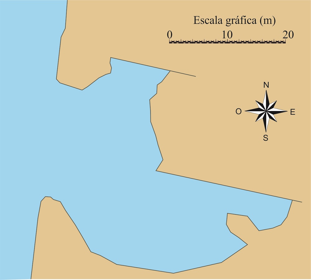
Floor plan of the Cova Blava. (modified from A.Martinez, 2015).
In the case of Sa Cova Blava, its structure is complex: and, although from the outside we see a single opening, its interior shows two parallel galleries. The gallery on the left has little development, while the other has a length of a little over a hundred metres.
The morphology of the two galleries is similar, in tent shape, in which the northern walls correspond to a fault planes developed in massive limestones and the southern walls are stratification planes of yellowish margo-limestones (see idealised diagram).
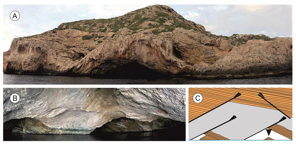
A) General panoramic view the Cova Blava, with its arch-shaped entrance. B) Panoramic view of its interior, showing its two galleries. C) Idealised diagram of the structure of the cave, showing the various geological elements of its origin.
While the massive limestones are apparently devoid of fossils, the stratified margo-limestones contain abundant fossils of ammonites, a now extinct type of mollusc very typical of the seas of the Jurassic (200-145 Ma). These can be observed in the ceiling of the cave, where the strata have been laid bare.
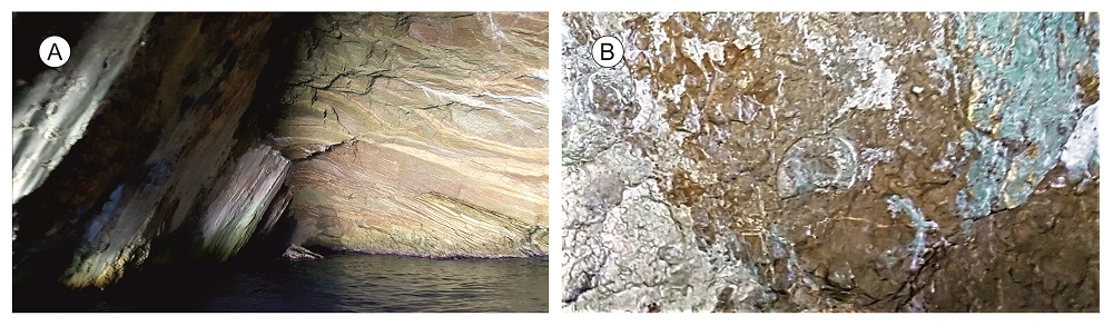
A) View of the larger gallery of Sa Cova Blava, showing the intersection between a fault plane (left) and the stratification planes of the margo-limestones (right). In the background, a block fallen from the ceiling which illustrates its formation process. B) One of the ammonite fossils visible in the ceiling of the same gallery.
Apart from the characteristics of the cave itself, the geology which has given rise to its formation is relevant and complex in equal parts.
In contrast with the great majority of faults presents in the rocks of the Balearics, a product of the formation of the islands, the faults we can see here were formed many millions of years before, when the territory formed part of a seabed.
200 Ma ago, the area which is today the Balearic Islands corresponded to a shallow seabed, in which the aforesaid massive limestones of the Lower Jurassic formed. Towards the end of this period, tectonic activity began to manifest itself, with a notable sinking of the seabed in some zones, which became deep seas. This process generated numerous faults and slopes that were increasingly unstable. At some moment of the Middle Jurassic (some 165 Ma ago), a large mass of limestones of the Lower Jurassic collapsed, causing an enormous avalanche which deposited on top of the deep-water sediments of the Middle Jurassic itself. The slid materials are called olistolites and they are very frequent in Cabrera.
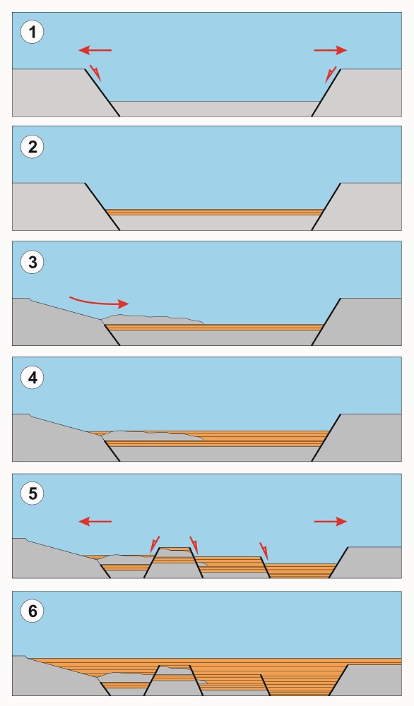
Idealised diagram of the evolution of the seabed during the Jurassic in the zone that today is Cabrera.
During the rest of the Jurassic, layer by layer, the sediments finally fossilised the remains of that avalanche at the same time that new faults were forming and fracturing the pre-existing materials. Finally, many millions of years later, 25 Ma ago, a new stage of intense geological activity known as the Alpine Orogeny would raise all those materials above the sea level.
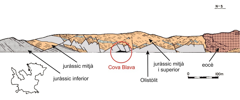
The geology of Cova Blava and its cliffs. Note how the entrance to the cave corresponds to a part of the deposit generated by an underwater avalanche of the Jurassic (olistolite) which during that period was fractured by fault and raised above the sea level by the Alpine Orogeny. Diagram modified from Sabat & Santanach (1984).
Finally, we should point out that the fault surface, we can observe in the cave, displays numerous striations and marks that help geologists to know its direction of movement. The polished surface of the fault is called a fault mirror.