The Puig de Sant Salvador, at 494,77 metres, is the highest peak of the southern zone of the Serres de Llevant, making it an excellent viewpoint for observing the structural relationship between the Marina de Llevant, the Serres de Llevant and the Central Plain.
At its summit there is a well-known sanctuary, reached by a narrow road.
There are three recommended viewpoints: the Creu des Picot, standing on the Puig des Milà; the monument to Christ-Rei, situated at one end of the Puig de Sant Salvador; and the terrace of the sanctuary.
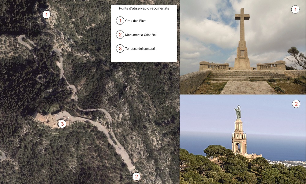
Situation of the viewpoints recommended.
From the cross there is an almost 360º panoramic view of the island.
In the distance there appears the Serra de Tramuntana, which has the island’s highest peaks, with the Puig Major at 1445 metres.
Between the Tramuntana range and the Serres de Llevant, where we are now, we can see a flat zone called the Central Plain, which is a depressed zone filled with Paleogene, Neogene and Quaternary materials with little or no deformation. This flat zone includes some small elevations like the Bonany or Randa hills, which form part of what are known as the Serres Centrals.
Towards the north we can make out the Bay of Alcúdia, below the northern foothills of the Serres de Llevant, which reach the highest point here at Sa Talaia Moreia (562 m).
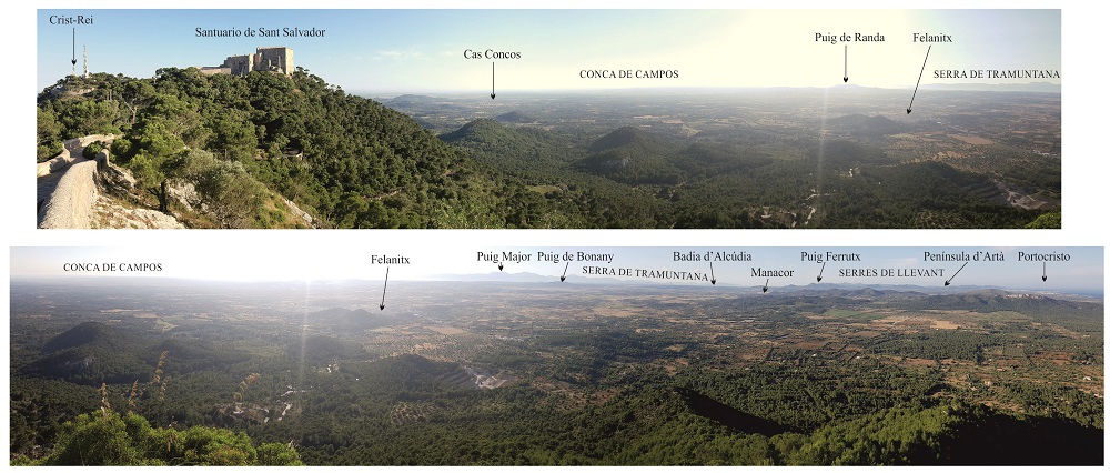
Panoramic view from the Creu des Picot.
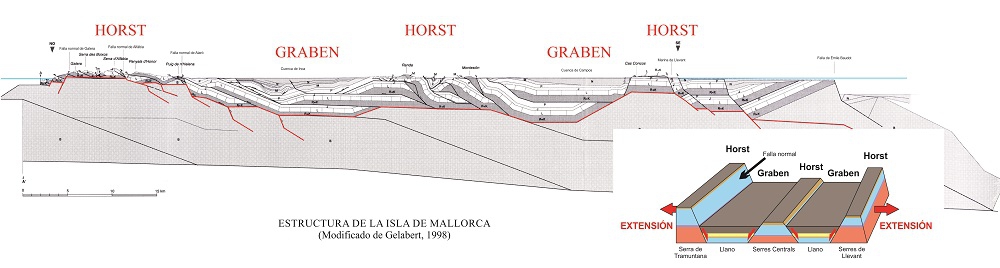
All of this is because the island is structured in elevated zones (horst) and depressed zones (graben), caused by the distension processes following the Alpine Orogeny.
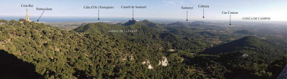
On the other hand, from the Crist-Rei it is possible to appreciate the Eastern and southern areas of the island, with the Marina de Llevant, the Puig de Santueri, the Campos Basin or, in the background on clear days, the Menorca Island (to the northeast) and the Cabrera archipelago (to the south). From the terrace of the monastery the south area is also appreciated.
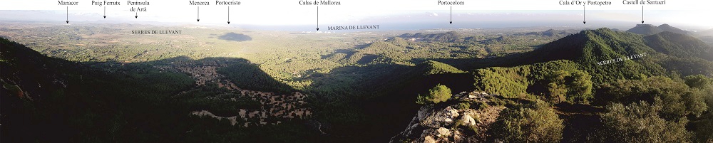
Panoramic view towards east, from Cris-Rei monument.
Panoramic view from the terrace of the sanctuary of Sant Salvador (same view than Crist-the King).
From these two viewpoints, four elements can be highlighted from the geological point of view:
- Between the Serres de Llevant and the sea, we can see a relatively flat fringe corresponding to the Marina de Llevant, consisting mainly of Sedimentary rock whose main component is calcium carbonate (CaCO3). Its origin can be chemical, organic or detritic.</p><p><br></p></div>">limestone materials from the Upper Miocene.
- The Puig de Santueri, which have tabular morphology and crowned by a medieval castle, correspond a tectonic Tectonic outcrop in the form of an isolated topographic elevation caused by the erosion of one or more thrust fault strata. The result is an outcrop of allochthonous material surrounded by autochthonous material, also named a tectonic island.</p></div>">klippe.
A tectonic Tectonic outcrop in the form of an isolated topographic elevation caused by the erosion of one or more thrust fault strata. The result is an outcrop of allochthonous material surrounded by autochthonous material, also named a tectonic island.</p></div>">klippe is formed when a mass of rock slides over another due to compression and is later eroded, leaving a vestige isolated from the mass of original rock. This geological structure is very common in the high reliefs of the Serres de Llevant.
In this occasion it is a set of hard materials from the Lower Jurassic (200-185 Ma) which form the summit of the mountain and rest directly on soft materials of the Lower Cretaceous (145-100 Ma).
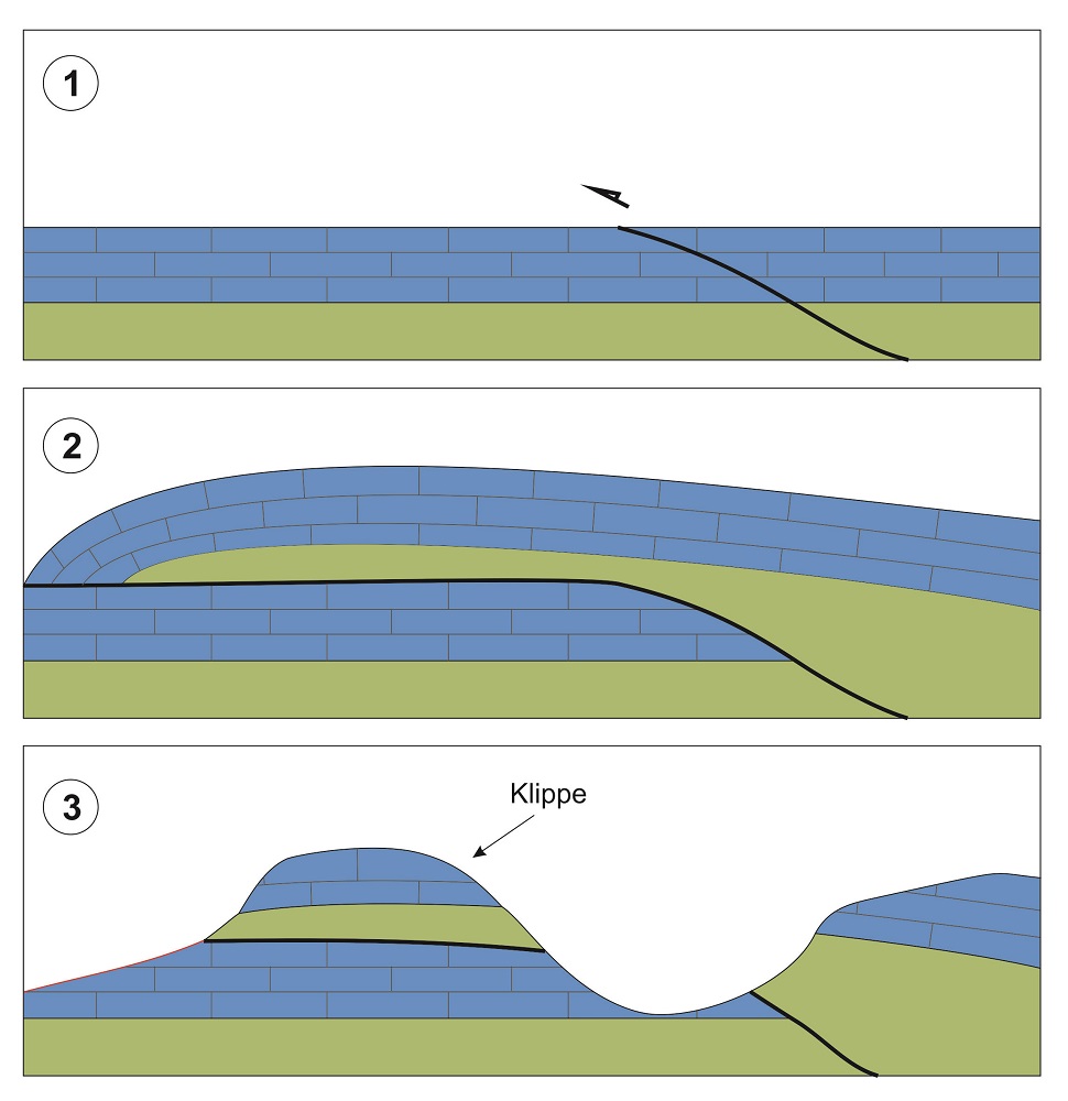
Diagram of the genesis of a tectonic klippe.
- The archipelago of Cabrera, which, as you can clearly see, corresponds geologically to the continuation of the Serres de Llevant.
Although the two zones are today geographically separated, during the last glacial period (which ended some 10,000 years ago) the archipelago was connected to Mallorca by land due to an abrupt lowering of the sea level.
- The Campos Basin, which is one of the island’s principal areas of sedimentation since it corresponds to a graben, a depressed zone in the island’s structure.
This basin was initially covered by the sea, but the fall of the sea level and the deposition of sediments finally formed the plain we know today.