| UTM-X | UTM-Y | ||
|---|---|---|---|
| STOP 1: LITTORAL DUNE CORDON OF ES CAVALLET | |||
| STOP 2: SES SALINES POOLS | |||
| STOP 3: ES CODOLAR LITTORAL CORDON |
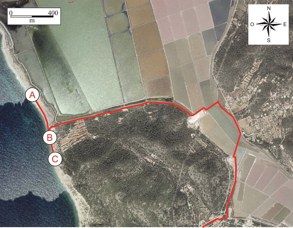
Recommended route for Es Codolar beach.
Es Codolar consists in a littoral bar formed by round pebbles that is still active today. It was originated during the Holocene age (10,000 years ago).
The beach is about 3 km long and its width varies between 9 and 80 m. It lies between Puig Falcó to the south-east and Punta de Can Toni Fita to the north-west and acts as a littoral bar, isolating a large part of the pools of Ses Salines.
According to the studies carried out in the zone, this littoral bar originated out of the erosion of the Jurassic limestones which tectonic, eustatic or antropical processes</span></p></div>">outcrop all over the sector of Puig Falcó and Cap des Falcó. The detached rocks were progressively rounded under the sea and deposited on the nearby shore by the littoral drift.
A gradation of measurements can be observed in the stones of Es Codolar, the largest and least rounded being located in the zones nearest to the source area. As the distance from the source area increases, the accumulated pebbles are smaller and rounder, since they have undergone impact for a longer time.
As already mentioned, a few millennia ago, the hills to the south-east of Es Codolar formed an islet, the erosion of which would create the littoral bar, modelled by the sea currents. In parallel, an alluvial fan
<div class="ql-editor"><p>Detritic deposit in the form of a fan or cone deposited by water due to an abrupt reduction in the slope of the surface over which it flows, also named dejection cone.</p></div>">alluvial fan was formed in the opposite sector, at Sa Caleta. The development of the two formations created a natural dyke along the coast, which caused the former marine zone located behind the bar to dry out and give rise to the present-day salt pans.It is documented that the Phoenicians exploited salt in Ses Salines, which suggests that Es Codolar was formed before their arrival in the island.
Just at the beginning of the escarpments in the south-east sector of Es Codolar there are outcrops of fossil beaches and dunes that display clear cross-stratification and rhizocretions (root moulds) which once covered the dunes. It is believed that they originated from the Pleistocene (Quaternary), meaning that they are approximately 2.6 million years old.
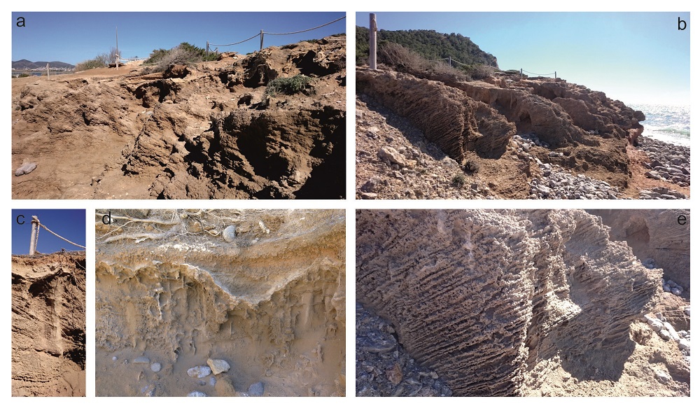
Photographs a and b: overall view of the outcrop of fossil beaches and dunes. Photographs c and d: detail of the root moulds. Photograph e: detail of the cross-stratification (point B).
Walking a little further towards the south-east of Es Codolar, either along the foot of the cliffs or along the top and after going down some stone steps, there is a recumbent fold that affects the Upper Jurassic-Lower Cretaceous materials.
These are rhythmic intercalations of marls and margo-limestones which have been folded giving rise to a recumbent and asymmetric synform that, later, has been eroded and Quaternary materials have been deposited on top.
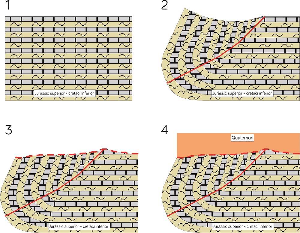
Reconstruction of the rhythmic folding and erosion process of marls and margo-limestones. The continuous red line marks the fold hinge. Steps 1 and 2.
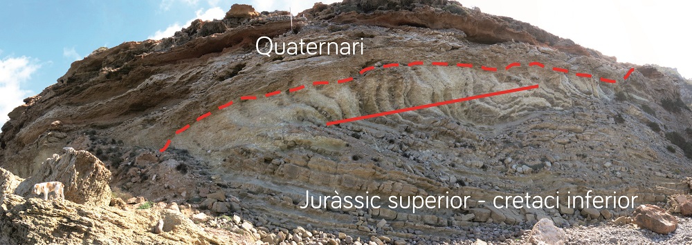
Recumbent fold where the continuous red line shows the hinge and the dashed line shows the erosive surface and contact between the Quaternary and Upper Jurassic- Lower Jurassic materials (point C).