| UTM-X | UTM-Y | ||
|---|---|---|---|
| STOP 1: PAS D’EN REVULL | |||
| STOP 2: BARRANC DES CANALÓ | |||
| STOP 3: MARÈS | |||
| STOP 4: ES TORRETÓ |
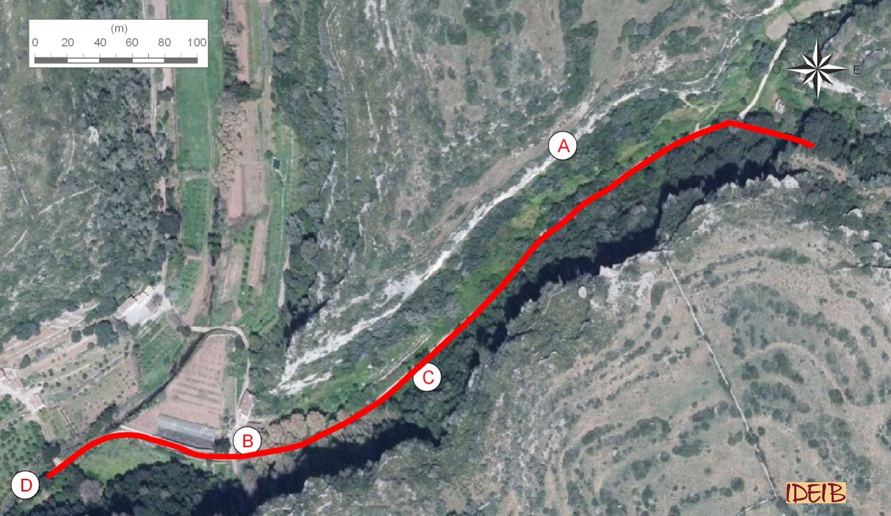
Suggested route to the stopping point.
Just as you leave Pas d’en Revull, you come to the Barranc des Canaló ravine on its eastern side, known as the Camí des Barranc. If you turn left, you will carry on entering the Barranc d'Algendar ravine and following the trail. If you turn right, you will go back to the car park.
As we have mentioned, Es Canaló is a tributary of the Barranc d'Algendar ravine, and its features are different from those of Pas d’en Revull, as it adopts the inherent form of the ravines of the central area of Menorca’s Migjorn region, wider and with very high and practically vertical walls.
As you descend Es Canaló, you will see on the walls to your right that there is land at their base that has been cultivated for many centuries. On this land, you can even see large stone blocks that have fallen from the cliff, and if you look at the walls, you will easily see blocks that are likely to fall. We can guess that these falls are helped by the roots of trees that grow on top of the cliff; as the tree roots grow, they widen the cracks and so contribute to blocks falling.
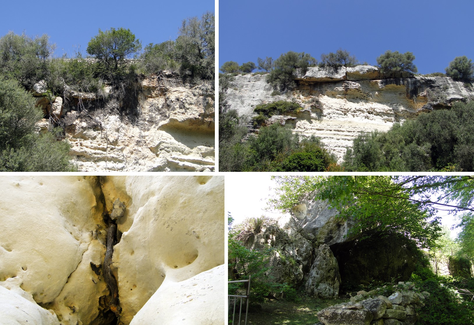
Top section of the Barranc des Canaló ravine, where recent falls have occurred, as shown by the abundant remains of soil and where the roots have been left exposed after the fall (point A), and blocks likely to fall at a nearby point. Below, close-up of a root that has opened up a passage between the rock and large fallen blocks at the end of Es Canaló next to the houses at Sant Antoni de s’Aranjassa (point B).
These blocks fall in free fall, vertically or almost vertically, from the blocks of rock that come away due to fractures and with the help of weathering processes. On occasion, the fall causes a turn around an axis below the centre of gravity of the unstable mass and they may be of large dimensions. These processes are another example of the different factors that take part in the formation of the ravine, where the erosion of both surface and subterranean water is complemented by the falling of blocks from the walls, which widen the ravine sideways.
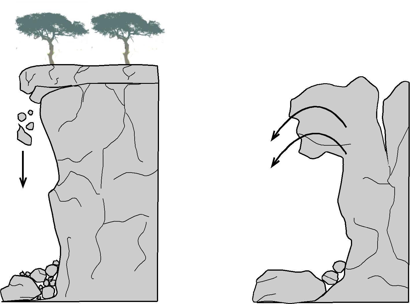
Examples of the types of movements that cause blocks to fall from the cliff faces of the ravine: vertical detachment of blocks as the cliff loses the grip of the infrajacent material (most common) influenced by weathering (such as the effect of tree roots that widen the cracks) and large rock falls.
The island of Menorca is a land that is very poor in surface water flows. Even so, the Algendar and Trebalúger ravines maintain a flow of water all year round. This is possible because they are supplied with subterranean water from the Migjorn aquifer, which literally springs up at numerous point along the river bed of its streams. This fact is due to the interception of the Top level of subterranean water where the hydraulic pressure is equal to the atmospheric pressure.</p><p><br></p></div>">water table (the upper part of the aquifer) with the surface of the land excavated thousands of years ago. When this interception occurs above the lamina of water of the stream, the water appears as springs.
Today, the Algendar ravine has the most springs of all Menorca’s ravines. There are 10 springs with water, with a greater or lesser flow, and records show that at least 6 have stopped gushing, all of which are in the upper reaches of the ravine. From the Puig de Santa Magdalena to Pla de Son Pruna there are no signs of water springs. On our trail, it is when you near the houses at Sant Antoni de s’Aranjassa that you will find the first springs. Consequently, near the path, you will see a pool from the Sant Antoni spring; you will not see a jet of water, but you will see that the rock is wet and that small water drops come away from it. It is said popularly of this spring that “sa roca sua aigua” (the rock sweats water). Taking a steep slope very near this, you will find the Font de ses Penyes spring. Both have been recovered through volunteer work. Next to the houses, the Font de s’Aranjassa spring reached a flow of 4,000 litres an hour in the 1960s. In 2014, this spring and the irrigation system associated with it were restored by the cleaning of the vegetation and sediment at the outflow of the spring by an organic farming project carried out by Caritas Diocesana, although unfortunately and logically with a much smaller flow than the earlier one.
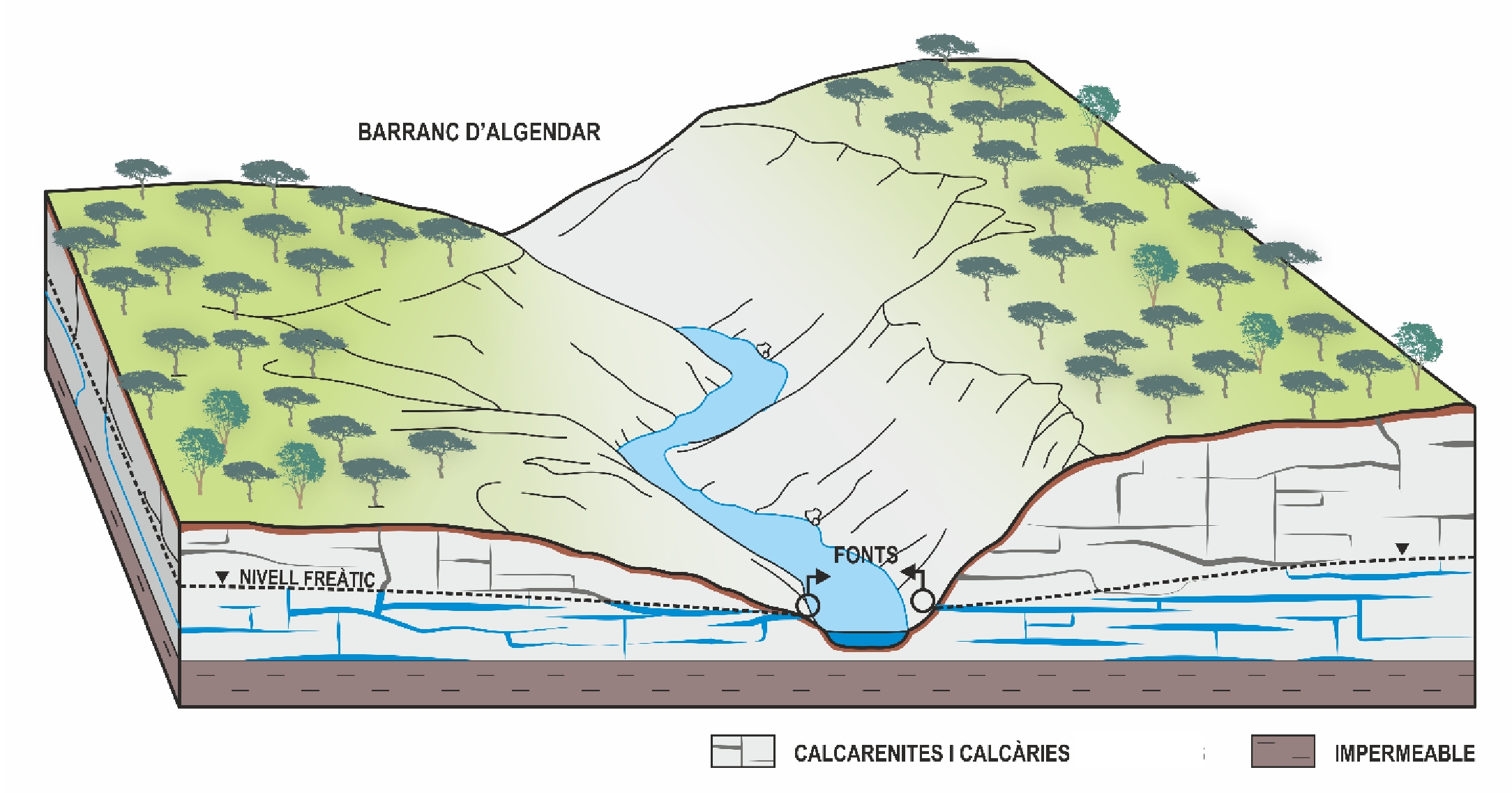
Diagram of the hydrogeological dynamics of the Barranc d’Algendar ravine. Excavation of the ravine causes the water table to intersect with the topographical surface and makes it possible for upwellings of freshwater to appear.
Following the path, after passing the houses at Sant Antoni de s’Aranjassa, you will find the widening of the river bed due to the union of two ravines (Algendar and Es Canaló) and the Algendar stream, which carries water all year round. At this point, the water comes from the unused surplus from irrigation from the S’Aranjassa, Son Pruna and Sobrevell springs. A little further down, the stream receives water from the Sa Dragonera spring, the only one in this higher section of the ravine that maintains a considerable flow.
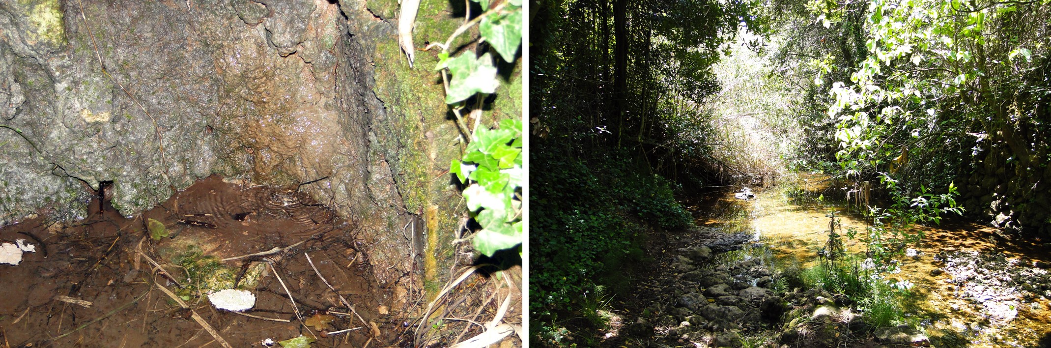
Sant Antoni spring next to Camí des Barranc (point C) and Algendar stream near the confluence between the main ravine and the Es Canaló ravine (point D).
Consequently, the predominant rock in the ravines, marès, is a permeable rock that allows water to infiltrate. Its accumulation allows the creation of an aquifer of vital importance to the island. The disappearance of the springs is a result of the depression of the Top level of subterranean water where the hydraulic pressure is equal to the atmospheric pressure.</p><p><br></p></div>">water table of the aquifer normally associated with its exploitation. However, the abandonment of the site and the subsequent growth in vegetation should be remembered, which, together with the finer sediment, can cause the disappearance of an upwelling, as shown by the recovered S’Aranjassa spring.
It should be considered that downstream, the stream varies its flow in both directions, in other words, despite receiving water from new springs, at some points, less water runs along its bed. This is due to the different behaviour of the stream, which goes from receiving water from the aquifer to giving it in some places where the Top level of subterranean water where the hydraulic pressure is equal to the atmospheric pressure.</p><p><br></p></div>">water table is lower.