| UTM-X | UTM-Y | ||
|---|---|---|---|
| STOP 1: THE FOSSIL DUNES | |||
| STOP 2: LIMESTONES WITH CRINOIDS | |||
| STOP 3: PHOSPHATE NODULES | |||
| STOP 4: ESCULL DES FRANCÈS | |||
| STOP 5: RED LLOSELLA | |||
| STOP 6: RADIOLARITES | |||
| STOP 7: THE CALESMORTS THRUST |
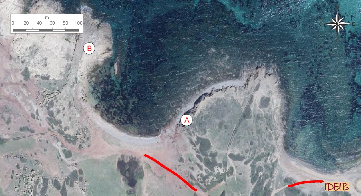
Access route to the stopping point.
The trail can optionally be completed by crossing the beach at Binimel·là heading towards the beach at Pregonda to observe two additional features around Calesmorts cove. When you reach this beach, you see a marked contrast in the colour of the rocks, going from the predominantly dark tones of the Binimel·là massif to reddish colourations. If you stand in the centre of the cove, it is especially interesting to look at how the severely folded dark rocks on the eastern side are superimposed on the red ones.
Sedimentary rocks are governed by a fairly simple principle known as superposition. This principle explains how the order of antiquity of sediments is established from bottom to top. To put it another way, we find the oldest rocks (the ones formed earlier) in the lower parts of a series of sedimentary rocks, while the more modern ones (formed later than the ones underneath) are in the upper parts. At Calesmorts we see that the older dark rocks of the Palaeozoic are on top of the more recent red ones, meaning the principle of superposition does not hold true here.
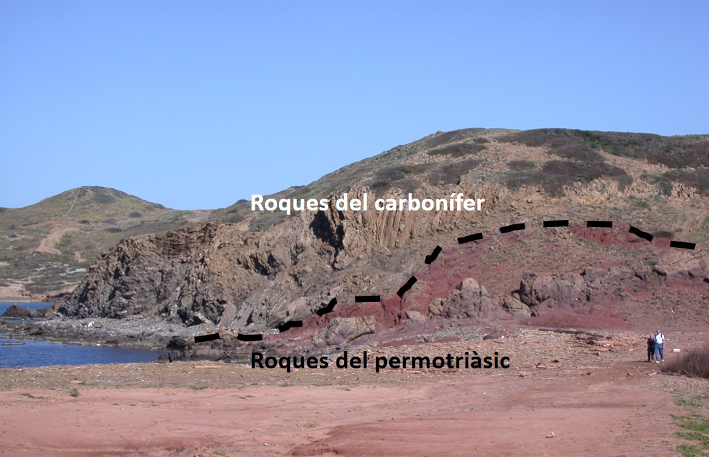
Thrust of the Carboniferous rocks on red sandstones and pelites from the Permian-Triassic at Calesmorts cove (point A).
The layout of the rocks that we find at Calesmorts is due to the action of a geological structure called a thrust. The action of colossal compressive forces on the Earth’s crust can cause the movement of the rocks that are in a lower position in such a way that the push can leave them situated on top, above more recent strata. The thrusts are a type of fault known as a reverse fault and are characterised by a horizontal movement with a low angle of inclination and movements that may be up to a few kilometres.
The Calesmorts thrust, which left the oldest rocks of the Carboniferous (Palaeozoic) on top of the more modern ones of the Permian-Triassic (Palaeozoic-Mesozoic), acted during the Cenozoic era. At that time, the Earth was subjected once again to huge movements caused by the collision between two large tectonic plates, in this case the African plate and the Eurasian plate, which threw up large mountain ranges such as the Alps, the Baetic Mountains and the Pyrenees.
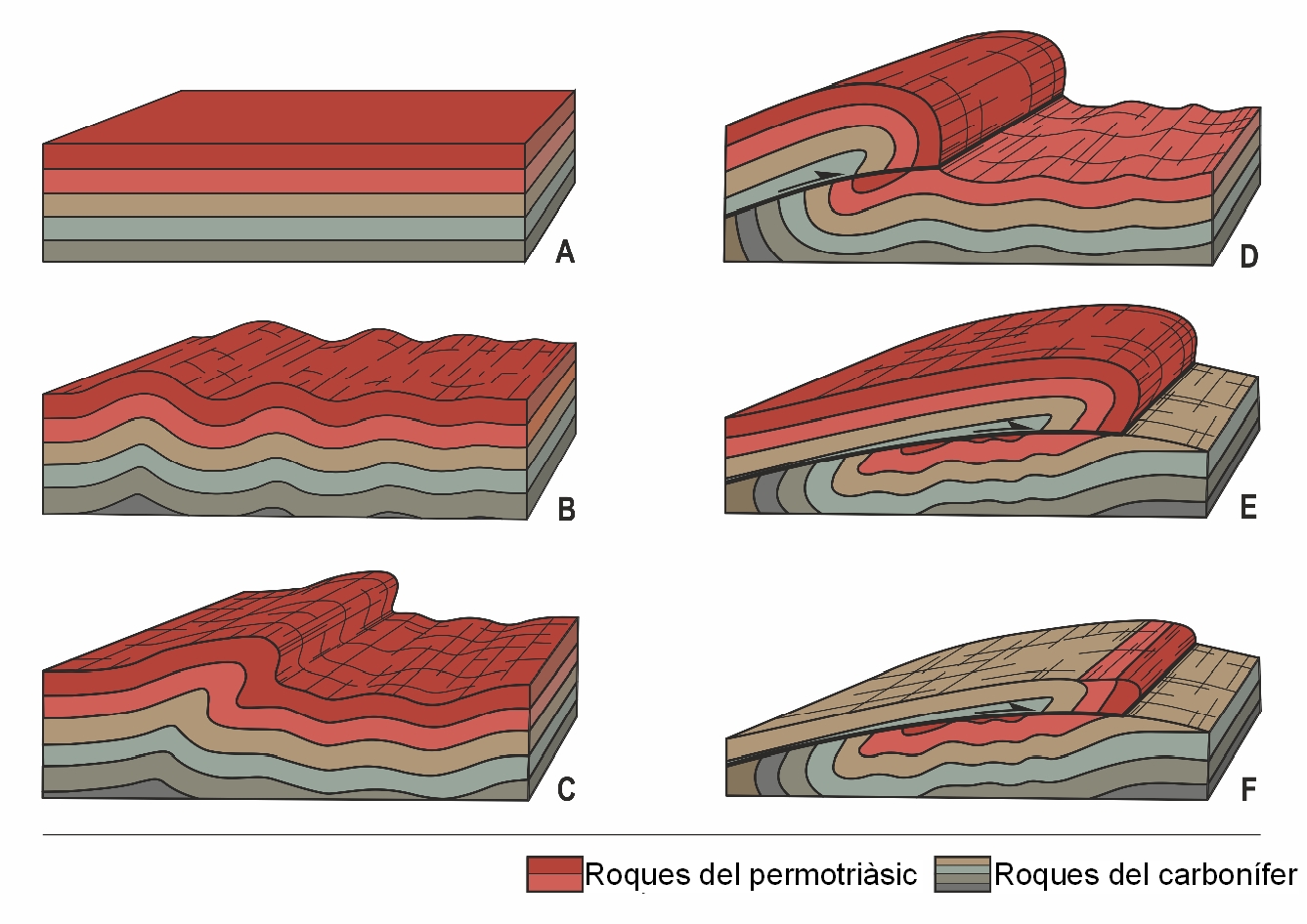
Evolution of the Calesmorts thrust. Originally, the oldest rocks (brown) were underneath the more modern ones (red). The action of immense forces compressed and folded the rocks, causing the initial order to become reversed over time and the dark rocks to lie on top of the red ones.
On the western side of Calesmorts cove, next to the fishermen’s refuge, the red materials are found underneath rocks of ochreish colourations corresponding to fossil dunes like the ones identified in the first stopping point on the trail. Skirting the coastline to the north, we see a new lithology: a rock of white and yellowish colourations that, if we examine them more closely, we can even see mineral crystals instead of grains of sand. It is a crystalline rock (an igneous rock) with abundant quartz, among other minerals, such as the whitish orthoclase, which can be found easily.
Today, its origin is not clear. The most widely-accepted opinion explains that these rocks are magmas from the Palaeozoic that, despite rising through fractures from inside the Earth to the surface, never emerged to the exterior through volcanic eruptions and, consequently, cooled down and solidified in the Earth’s interior, creating the rocks in this area. The rising of the great mountains at the end of this era allowed them to go from the seabed to become landmass.
They are usually in an advanced state of alteration. One of the most characteristic manifestations of this alteration is what is known as alveolar or honeycomb erosion, where the differences in hardness of the rock itself gives rise to the hardest parts standing out in the face of the process of erosion. In any event, they are very resistant rocks and, consequently, they stand out in the landscape, leading to the relief of Pregonda and the Bledes Islands. Their rather yellowish or ochreish colour causes the sand caused by their erosion to have a golden appearance under the water, which is what makes Pregonda such a unique beach
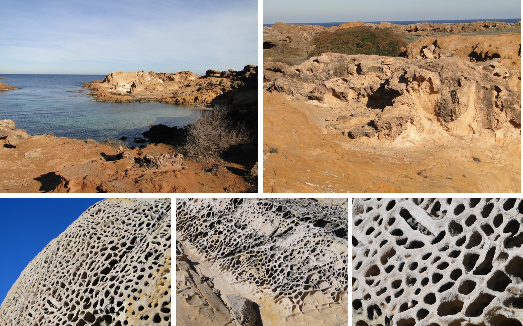
Rocks of volcanic origin in the area around Pregonda and close-up of the erosion with honeycomb shapes that these rocks usually display (point B).